Weather Alert in Hawaii
Red Flag Warning issued August 3 at 3:18AM HST until August 3 at 6:00PM HST by NWS Honolulu HI
AREAS AFFECTED: Niihau; Kauai South; Kauai Southwest; East Honolulu; Honolulu Metro; Ewa Plain; Waianae Coast; Oahu North Shore; Central Oahu; Waianae Mountains; Molokai North; Molokai West; Molokai Leeward South; Lanai Windward; Lanai Leeward; Lanai South; Lanai Mauka; Kahoolawe; Maui Leeward West; Maui Central Valley North; Maui Central Valley South; South Maui/Upcountry; South Haleakala; Big Island South; Big Island Southeast; Kohala; Big Island Interior
DESCRIPTION: ...A RED FLAG WARNING REMAINS IN EFFECT THROUGH THIS AFTERNOON FOR GUSTY WINDS AND LOW HUMIDITIES... .Dry and locally windy trade winds will produce critical fire weather conditions through this afternoon. Winds will be strongest over and downwind of higher terrain...especially this afternoon. While winds will begin a slowly decline later today, critical fire weather conditions are expected as dry weather persists over leeward areas. * AFFECTED AREA...Leeward areas of the Hawaiian Islands and interior sections of Big Island. * TIMING...Until 6 PM HST this evening. * WINDS...East 15 to 25 mph with gusts up to 40 mph. * RELATIVE HUMIDITY...Lower 40s to near 50 percent. * IMPACTS...A combination of strong winds, low relative humidity, and dry fuels can contribute to extreme fire behavior. Any fires that develop will rapidly spread. A Red Flag Warning does not predict the commencement of new fires.
INSTRUCTION: Outdoor burning is not recommended. Heat from vehicle exhaust systems can ignite dry grass. Park cars on areas that are paved or where vegetation is trimmed and cleared. High winds contribute to wildfire hazard. Delay activities that could throw off sparks until the wind dies down. A Red Flag Warning means that critical fire weather conditions are either occurring now or will shortly. A combination of strong winds, low relative humidity, and warm temperatures can contribute to extreme fire behavior. A Red Flag Warning does not predict new fire starts.
Want more detail? Get the Complete 7 Day and Night Detailed Forecast!
Current U.S. National Radar--Current
The Current National Weather Radar is shown below with a UTC Time (subtract 5 hours from UTC to get Eastern Time).

National Weather Forecast--Current
The Current National Weather Forecast and National Weather Map are shown below.

National Weather Forecast for Tomorrow
Tomorrow National Weather Forecast and Tomorrow National Weather Map are show below.

North America Water Vapor (Moisture)
This map shows recent moisture content over North America. Bright and colored areas show high moisture (ie, clouds); brown indicates very little moisture present; black indicates no moisture.

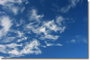
Weather Topic: What are Cirrostratus Clouds?
Home - Education - Cloud Types - Cirrostratus Clouds
 Next Topic: Cirrus Clouds
Cirrostratus clouds are high, thin clouds that form above
20,000 feet and are made mostly of ice crystals. They sometimes look like giant
feathers, horse tails, or curls of hair in the sky.
These clouds are pushed by the jet stream and can move at high speeds reaching
100 mph.
What do they indicate?
They indicate that a precipitation is likely within 24 hours.
Next Topic: Cirrus Clouds
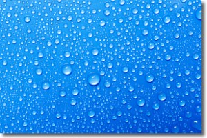
Weather Topic: What is Condensation?
Home - Education - Precipitation - Condensation
 Next Topic: Contrails
Condensation is the process which creates clouds, and therefore
it is a crucial process in the water cycle.
Condensation is the change of matter from a state of gas into a state of liquid,
and it happens because water molecules release heat into the atmosphere and
become organized into a more closely packed structure, what we might see as
water droplets.
Water is always present in the air around us as a vapor, but it's too small for
us to see. When water undergoes the process of condensation it becomes organized
into visible water droplets. You've probably seen condensation happen before on the
surface of a cold drink!
Next Topic: Contrails
Current conditions powered by WeatherAPI.com


