Weather Alert in Alaska
Winter Weather Advisory issued March 22 at 4:16AM AKDT until March 22 at 10:00AM AKDT by NWS Juneau AK
AREAS AFFECTED: City and Borough of Yakutat
DESCRIPTION: ...NUMEROUS SNOW SHOWERS CONTINUE THROUGH SUNDAY MORNING, SECOND ROUND OF SNOW EXPECTED FOR THE SOUTHERN PANHANDLE BY SUNDAY AFTERNOON... .Another band of snow is pushing into Yakutat this morning with reported visibilities as low as one-half mile ongoing. This band will continue to move northwestward out of the area through early Sunday morning. In its wake, the hit or miss snow showers we have seen the previous week will return along the back side of this front with periods of light to moderate snow expected, the winter weather advisories have been extended through late Sunday morning for the northern panhandle. Snow will gradually end across the northern panhandle through Sunday afternoon with longer duration advisories continuing for portions of the far southern panhandle. Snowfall accumulations will be variable across the area due to the hit or miss nature of these showers. Rates as high as 1 inch per hour and visibilities down to 1 mile or less will be possible within any heavier showers that repeatedly move over the same location. These showers can also bring infrequent periods of increased wind gusts up to 40 mph. For the southern panhandle communities, temperatures are expected to start cooling through Sunday with bands of snow moving through the southern and central panhandle by the afternoon into Sunday night, prompting the longer duration Winter Weather Advisory. Accumulations in the south will be the highest on the higher elevations of Prince of Wales Island midday Sunday, but more accumulations expected at sea level by Sunday evening and night as temperatures cool through Sunday evening. * WHAT...Snow. Additional snow accumulations up to two inches. Total snow accumulations of 4 to 7 inches. Visibilities reduced to 1 mile or less. Winds gusting as high as 35 mph. * WHERE...City and Borough of Yakutat. * WHEN...Until 10 AM AKDT this morning. * IMPACTS...Plan on slippery conditions. * ADDITIONAL DETAILS...Snow showers will then continue to be intermittent through Sunday morning on the back side of the front. Visibilities will be reduced to 1 mile or less in heavier snow.
INSTRUCTION: Slow down and use caution while traveling. People are urged to prepare their property before the onset of winter weather. For the latest road conditions, where available, call 5 1 1 or visit 511.alaska.gov.
Want more detail? Get the Complete 7 Day and Night Detailed Forecast!
Current U.S. National Radar--Current
The Current National Weather Radar is shown below with a UTC Time (subtract 5 hours from UTC to get Eastern Time).

National Weather Forecast--Current
The Current National Weather Forecast and National Weather Map are shown below.

National Weather Forecast for Tomorrow
Tomorrow National Weather Forecast and Tomorrow National Weather Map are show below.

North America Water Vapor (Moisture)
This map shows recent moisture content over North America. Bright and colored areas show high moisture (ie, clouds); brown indicates very little moisture present; black indicates no moisture.

Weather Topic: What are Cirrus Clouds?
Home - Education - Cloud Types - Cirrus Clouds
 Next Topic: Condensation
Cirrus clouds are high-level clouds that occur above 20,000 feet
and are composed mainly of ice crystals.
They are thin and wispy in appearance.
What do they indicate?
They are often the first sign of an approaching storm.
Next Topic: Condensation
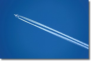
Weather Topic: What are Contrails?
Home - Education - Cloud Types - Contrails
 Next Topic: Cumulonimbus Clouds
A contrail is an artificial cloud, created by the passing of an
aircraft.
Contrails form because water vapor in the exhaust of aircraft engines is suspended
in the air under certain temperatures and humidity conditions. These contrails
are called exhaust contrails.
Another type of contrail can form due to a temporary reduction in air pressure
moving over the plane's surface, causing condensation.
These are called aerodynamic contrails.
When you can see your breath on a cold day, it is also because of condensation.
The reason contrails last longer than the condensation from your breath is
because the water in contrails freezes into ice particles.
Next Topic: Cumulonimbus Clouds
Current conditions powered by WeatherAPI.com


