Weather Alert in Colorado
Flood Watch issued August 26 at 2:57AM MDT until August 27 at 12:00AM MDT by NWS Grand Junction CO
AREAS AFFECTED: Roan and Tavaputs Plateaus; Grand Valley; Debeque to Silt Corridor; Central Colorado River Basin; Grand and Battlement Mesas; Gore and Elk Mountains/Central Mountain Valleys; Central Gunnison and Uncompahgre River Basin; West Elk and Sawatch Mountains; Flat Tops; Upper Gunnison River Valley; Uncompahgre Plateau/Dallas Divide; Northwestern San Juan Mountains; Southwest San Juan Mountains; Paradox Valley/Lower Dolores River; Four Corners/Upper Dolores River; Animas River Basin; San Juan River Basin; Southeast Utah; La Sal and Abajo Mountains; Canyonlands/Natural Bridges
DESCRIPTION: * WHAT...Flash flooding caused by excessive rainfall continues to be possible. * WHERE...Portions of Colorado, including the following areas, along the I-70 corridor, Flat Tops, Four Corners, Central Mountain Valleys, Grand Valley, Grand and Battlement Mesas, Western San Juan Mountains, Uncompahgre Plateau and Dallas Divide, Upper Gunnison River Valley and West Elk and Sawatch Mountains, and portions of southeast Utah, including the following areas, Canyonlands/Natural Bridges and the La Sal and Abajo Mountains. This also includes the Elk/Lee Complex, Turner Gulch, Deer Creek, Stoner Mesa, and South Rim burn scars. * WHEN...From 6 AM MDT this morning through this evening. * IMPACTS...Excessive runoff may result in flooding of rivers, creeks, streams, and other low-lying and flood-prone locations. Area creeks and streams are running high and could flood with more heavy rain. Heavy rain over burn scars may lead to debris flows. * ADDITIONAL DETAILS... - http://www.weather.gov/safety/flood
INSTRUCTION: You should monitor later forecasts and be prepared to take action should Flash Flood Warnings be issued.
Want more detail? Get the Complete 7 Day and Night Detailed Forecast!
Current U.S. National Radar--Current
The Current National Weather Radar is shown below with a UTC Time (subtract 5 hours from UTC to get Eastern Time).

National Weather Forecast--Current
The Current National Weather Forecast and National Weather Map are shown below.

National Weather Forecast for Tomorrow
Tomorrow National Weather Forecast and Tomorrow National Weather Map are show below.

North America Water Vapor (Moisture)
This map shows recent moisture content over North America. Bright and colored areas show high moisture (ie, clouds); brown indicates very little moisture present; black indicates no moisture.

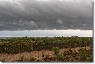
Weather Topic: What are Shelf Clouds?
Home - Education - Cloud Types - Shelf Clouds
 Next Topic: Sleet
A shelf cloud is similar to a wall cloud, but forms at the front
of a storm cloud, instead of at the rear, where wall clouds form.
A shelf cloud is caused by a series of events set into motion by the advancing
storm; first, cool air settles along the ground where precipitation has just fallen.
As the cool air is brought in, the warmer air is displaced, and rises above it,
because it is less dense. When the warmer air reaches the bottom of the storm cloud,
it begins to cool again, and the resulting condensation is a visible shelf cloud.
Next Topic: Sleet
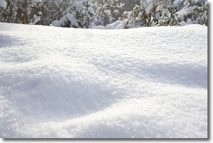
Weather Topic: What is Snow?
Home - Education - Precipitation - Snow
 Next Topic: Stratocumulus Clouds
Snow is precipitation taking the form of ice crystals. Each ice crystal, or snowflake,
has unique characteristics, but all of them grow in a hexagonal structure.
Snowfall can last for sustained periods of time and result in significant buildup
of snow on the ground.
On the earth's surface, snow starts out light and powdery, but as it begins to melt
it tends to become more granular, producing small bits of ice which have the consistency of
sand. After several cycles of melting and freezing, snow can become very dense
and ice-like, commonly known as snow pack.
Next Topic: Stratocumulus Clouds
Current conditions powered by WeatherAPI.com


