Weather Alert in Idaho
Winter Weather Advisory issued February 23 at 11:28AM MST until February 25 at 5:00PM MST by NWS Pocatello ID
AREAS AFFECTED: Sawtooth/Stanley Basin; Sun Valley Region; Big Lost Highlands/Copper Basin
DESCRIPTION: * WHAT...Moderate to heavy snow expected above 7000 feet. Total snow accumulations between 7 and 17 inches. Amounts exceeding 2 feet are possible across the Sawtooths. Winds gusts up to 35 mph are possible, peaking in excess of 45 mph Tuesday night and Wednesday morning. * WHERE...Big Lost Highlands/Copper Basin, Sawtooth/Stanley Basin, and Sun Valley Region. * WHEN...From 5 PM this afternoon to 5 PM MST Wednesday. * IMPACTS...Travel could be very difficult. Some blowing and drifting snow is expected, especially in exposed areas and higher ridgetops.
INSTRUCTION: Slow down and use caution while traveling. Call 5 1 1 or visit 511.idaho.gov for the latest road conditions.
Want more detail? Get the Complete 7 Day and Night Detailed Forecast!
Current U.S. National Radar--Current
The Current National Weather Radar is shown below with a UTC Time (subtract 5 hours from UTC to get Eastern Time).

National Weather Forecast--Current
The Current National Weather Forecast and National Weather Map are shown below.

National Weather Forecast for Tomorrow
Tomorrow National Weather Forecast and Tomorrow National Weather Map are show below.

North America Water Vapor (Moisture)
This map shows recent moisture content over North America. Bright and colored areas show high moisture (ie, clouds); brown indicates very little moisture present; black indicates no moisture.

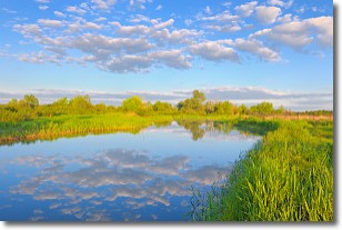
Weather Topic: What are Stratocumulus Clouds?
Home - Education - Cloud Types - Stratocumulus Clouds
 Next Topic: Stratus Clouds
Stratocumulus clouds are similar to altocumulus clouds in their
fluffy appearance, but have a slightly darker shade due to their additional mass.
A good way to distinguish the two cloud types is to hold your hand out and measure
the size of an individual cloud; if it is the size of your thumb it is generally
an altocumulus cloud, if it is the size of your hand it is generally a
stratocumulus cloud.
It is uncommon for stratocumulus clouds to produce precipitation, but if they do
it is usually a light rain or snow.
Next Topic: Stratus Clouds
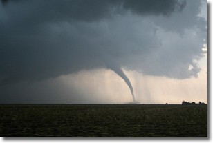
Weather Topic: What are Wall Clouds?
Home - Education - Cloud Types - Wall Clouds
 Next Topic: Altocumulus Clouds
A wall cloud forms underneath the base of a cumulonimbus cloud,
and can be a hotbed for deadly tornadoes.
Wall clouds are formed by air flowing into the cumulonimbus clouds, which can
result in the wall cloud descending from the base of the cumulonimbus cloud, or
rising fractus clouds which join to the base of the storm cloud as the wall cloud
takes shape.
Wall clouds can be very large, and in the Northern Hemisphere they generally
form at the southern edge of cumulonimbus clouds.
Next Topic: Altocumulus Clouds
Current conditions powered by WeatherAPI.com


