Weather Alert in Wisconsin
Winter Weather Advisory issued April 1 at 9:02PM CDT until April 2 at 10:00AM CDT by NWS La Crosse WI
AREAS AFFECTED: Trempealeau; La Crosse; Monroe; Juneau; Adams; Vernon; Richland
DESCRIPTION: ...FREEZING RAIN IMPACTS THE AREA FROM TONIGHT INTO THURSDAY MORNING... .Freezing rain will develop overnight and persists into Thursday morning. it will end from south to north through the morning hours. Greatest ice accumulations are forecast along and north of Interstate 94 with icing amounts of a quarter to nearly half an inch possible in a few locations. Closer to Interstate 90, impacts vary more in space and time with ridge tops and bridges possibly seeing more impacts versus the valleys and ground. * WHAT...Mixed precipitation expected. Total snow accumulations up to one inch and ice accumulations around three tenths of an inch. * WHERE...Portions of central, southwest, and west central Wisconsin. * WHEN...From midnight tonight to 10 AM CDT Thursday. * IMPACTS...Power outages and tree damage are possible due to the ice. Travel could be nearly impossible. The hazardous conditions could impact the Thursday morning commute.
INSTRUCTION: Slow down and use caution while traveling. Visit 511wi.gov for road conditions.
Want more detail? Get the Complete 7 Day and Night Detailed Forecast!
Current U.S. National Radar--Current
The Current National Weather Radar is shown below with a UTC Time (subtract 5 hours from UTC to get Eastern Time).

National Weather Forecast--Current
The Current National Weather Forecast and National Weather Map are shown below.

National Weather Forecast for Tomorrow
Tomorrow National Weather Forecast and Tomorrow National Weather Map are show below.

North America Water Vapor (Moisture)
This map shows recent moisture content over North America. Bright and colored areas show high moisture (ie, clouds); brown indicates very little moisture present; black indicates no moisture.

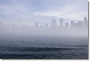
Weather Topic: What is Fog?
Home - Education - Cloud Types - Fog
 Next Topic: Fractus Clouds
Fog is technically a type of stratus cloud, which lies along the
ground and obscures visibility.
It is usually created when humidity in the air condenses into tiny water droplets.
Because of this, some places are more prone to foggy weather, such as regions
close to a body of water.
Fog is similar to mist; both are the appearance of water droplets suspended in
the air, but fog is the term applied to the condition when visibility is less than 1 km.
Next Topic: Fractus Clouds
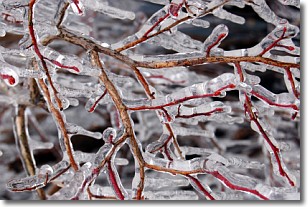
Weather Topic: What is Freezing Rain?
Home - Education - Precipitation - Freezing Rain
 Next Topic: Graupel
Freezing rain is a condition where precipitation which has fallen in the form of
water droplets reaches temperatures which are below freezing and freezes upon
coming into contact
with surface objects. The result of this precipitation is a glaze of ice which
can be damaging to plants and man-made structures. A severe onset of freezing
rain which results in a very thick glaze of ice is known as an ice storm.
Next Topic: Graupel
Current conditions powered by WeatherAPI.com


