Weather Alert in New York
Special Weather Statement issued February 25 at 9:31PM EST by NWS Albany NY
AREAS AFFECTED: Southern Fulton; Montgomery; Northern Saratoga; Schoharie; Western Schenectady; Eastern Schenectady; Southern Saratoga; Western Albany; Eastern Albany; Western Rensselaer; Eastern Rensselaer; Western Greene; Eastern Greene; Western Columbia; Eastern Columbia
DESCRIPTION: HAZARDS...An area of heavy snow which can reduce visibility to less than one mile. LOCATION AND MOVEMENT...At 930 PM EST, an area of heavy snow was over Niskayuna, or over Schenectady moving east at 40 MPH. LOCATIONS IMPACTED INCLUDE... Albany, Schenectady, Troy, Clifton Park, Rotterdam, Saratoga Springs, Amsterdam, East Greenbush, Cohoes, Watervliet, Rensselaer, Colonie, Scotia, Mechanicville, Cobleskill, Nassau, Fonda, Delmar, Latham, and Jefferson. This includes the following highways... Interstate 88 between exits 20 and 25. Interstate 90 between exits 10 and 28. Interstate 890 between exits 1a and 9. Interstate 87 between exits 21B and 7, and between exits 8A and 15. Interstate 787 between exits 1 and 9. SAFETY INFO... Conditions can deteriorate rapidly in winter weather situations. Be prepared for snow or ice covered roads. Slow down and allow extra time to reach your destination.
INSTRUCTION: N/A
Want more detail? Get the Complete 7 Day and Night Detailed Forecast!
Current U.S. National Radar--Current
The Current National Weather Radar is shown below with a UTC Time (subtract 5 hours from UTC to get Eastern Time).

National Weather Forecast--Current
The Current National Weather Forecast and National Weather Map are shown below.

National Weather Forecast for Tomorrow
Tomorrow National Weather Forecast and Tomorrow National Weather Map are show below.

North America Water Vapor (Moisture)
This map shows recent moisture content over North America. Bright and colored areas show high moisture (ie, clouds); brown indicates very little moisture present; black indicates no moisture.

Weather Topic: What are Contrails?
Home - Education - Cloud Types - Contrails
 Next Topic: Cumulonimbus Clouds
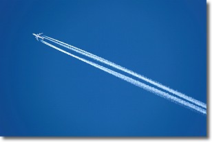
A contrail is an artificial cloud, created by the passing of an
aircraft.
Contrails form because water vapor in the exhaust of aircraft engines is suspended
in the air under certain temperatures and humidity conditions. These contrails
are called exhaust contrails.
Another type of contrail can form due to a temporary reduction in air pressure
moving over the plane's surface, causing condensation.
These are called aerodynamic contrails.
When you can see your breath on a cold day, it is also because of condensation.
The reason contrails last longer than the condensation from your breath is
because the water in contrails freezes into ice particles.
Next Topic: Cumulonimbus Clouds
Weather Topic: What are Cumulus Clouds?
Home - Education - Cloud Types - Cumulus Clouds
 Next Topic: Drizzle
Cumulus clouds are fluffy and textured with rounded tops, and
may have flat bottoms. The border of a cumulus cloud
is clearly defined, and can have the appearance of cotton or cauliflower.
Cumulus clouds form at low altitudes (rarely above 2 km) but can grow very tall,
becoming cumulus congestus and possibly the even taller cumulonimbus clouds.
When cumulus clouds become taller, they have a greater chance of producing precipitation.
Next Topic: Drizzle
Current conditions powered by WeatherAPI.com


