Weather Alert in Arizona
Flash Flood Warning issued September 4 at 5:14PM MST until September 4 at 8:15PM MST by NWS Flagstaff AZ
AREAS AFFECTED: Coconino, AZ
DESCRIPTION: FFWFGZ The National Weather Service in Flagstaff has issued a * Flash Flood Warning for... Coconino County in north central Arizona...this includes the Colorado River between river miles 49 and 54. * Until 815 PM MST /915 PM MDT/. * At 514 PM MST /614 PM MDT/, Doppler radar indicated thunderstorms producing heavy rain over and just north of Nankoweap Creek. This is the second round of storms in this area today. Flash flooding is ongoing or expected to begin shortly. HAZARD...Life threatening flash flooding. Thunderstorms producing flash flooding. SOURCE...Radar indicated. IMPACT...Life threatening flash flooding of creeks and streams and normally dry washes. * Some locations that will experience flash flooding include... Grand Canyon National Park and Saddle Mountain Wilderness. This includes the Colorado River between river miles 49 and 54. This includes the following recreation areas and campgrounds... Dinosaur Camp Site, Little Nankoweap Camp Site, Upper Nankoweap Camp Site, Main Nankoweap Camp Site and Lower Nankoweap Camp Site. This includes the following creeks, washes and rivers... Nankoweap Creek, Saddle Canyon, Colorado River, Nankoweap Canyon, Tatahoysa Wash and Little Nankoweap Creek.
INSTRUCTION: Flooding of washes and creeks will occur, some dirt roads will become muddy and impassable. Paved roads and underpasses could become flooded as well.
Want more detail? Get the Complete 7 Day and Night Detailed Forecast!
Current U.S. National Radar--Current
The Current National Weather Radar is shown below with a UTC Time (subtract 5 hours from UTC to get Eastern Time).

National Weather Forecast--Current
The Current National Weather Forecast and National Weather Map are shown below.

National Weather Forecast for Tomorrow
Tomorrow National Weather Forecast and Tomorrow National Weather Map are show below.

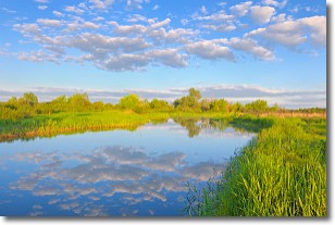
North America Water Vapor (Moisture)
This map shows recent moisture content over North America. Bright and colored areas show high moisture (ie, clouds); brown indicates very little moisture present; black indicates no moisture.

Weather Topic: What are Stratocumulus Clouds?
Home - Education - Cloud Types - Stratocumulus Clouds
 Next Topic: Stratus Clouds
Stratocumulus clouds are similar to altocumulus clouds in their
fluffy appearance, but have a slightly darker shade due to their additional mass.
A good way to distinguish the two cloud types is to hold your hand out and measure
the size of an individual cloud; if it is the size of your thumb it is generally
an altocumulus cloud, if it is the size of your hand it is generally a
stratocumulus cloud.
It is uncommon for stratocumulus clouds to produce precipitation, but if they do
it is usually a light rain or snow.
Next Topic: Stratus Clouds
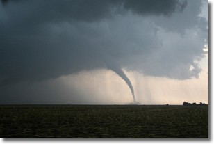
Weather Topic: What are Wall Clouds?
Home - Education - Cloud Types - Wall Clouds
 Next Topic: Altocumulus Clouds
A wall cloud forms underneath the base of a cumulonimbus cloud,
and can be a hotbed for deadly tornadoes.
Wall clouds are formed by air flowing into the cumulonimbus clouds, which can
result in the wall cloud descending from the base of the cumulonimbus cloud, or
rising fractus clouds which join to the base of the storm cloud as the wall cloud
takes shape.
Wall clouds can be very large, and in the Northern Hemisphere they generally
form at the southern edge of cumulonimbus clouds.
Next Topic: Altocumulus Clouds
Current conditions powered by WeatherAPI.com


