Weather Alert in Virginia
Severe Thunderstorm Warning issued September 4 at 12:59PM EDT until September 4 at 2:00PM EDT by NWS Blacksburg VA
AREAS AFFECTED: Bland, VA; Craig, VA; Giles, VA; Greenbrier, WV; Mercer, WV; Monroe, WV; Summers, WV
DESCRIPTION: SVRRNK The National Weather Service in BLACKSBURG has issued a * Severe Thunderstorm Warning for... Giles County in southwestern Virginia... Southwestern Craig County in southwestern Virginia... Northeastern Bland County in southwestern Virginia... South central Greenbrier County in southeastern West Virginia... Southeastern Summers County in southeastern West Virginia... Southeastern Mercer County in southeastern West Virginia... Monroe County in southeastern West Virginia... * Until 200 PM EDT. * At 1259 PM EDT, a severe thunderstorm was located over Oakvale, or 7 miles northeast of Rocky Gap, moving northeast at 40 mph. HAZARD...60 mph wind gusts. SOURCE...Radar indicated. IMPACT...Expect damage to roofs, siding, and trees. * Locations impacted include... Princeton... Pearisburg... Narrows... Alderson... Pembroke... Athens... and Peterstown.
INSTRUCTION: Prepare immediately for damaging winds. For your safety, move to an interior room on the lowest floor of a sturdy building. Stay away from windows. When it is safe to do so, please send your reports of hail of any size, as well as reports of any wind damage, including downed trees or large limbs, to the National Weather Service by calling toll free at 1...8 6 6...2 1 5...4 3 2 4. Reports and pictures can also be shared on the National Weather Service Blacksburg Facebook page and on X.
Want more detail? Get the Complete 7 Day and Night Detailed Forecast!
Current U.S. National Radar--Current
The Current National Weather Radar is shown below with a UTC Time (subtract 5 hours from UTC to get Eastern Time).

National Weather Forecast--Current
The Current National Weather Forecast and National Weather Map are shown below.

National Weather Forecast for Tomorrow
Tomorrow National Weather Forecast and Tomorrow National Weather Map are show below.

North America Water Vapor (Moisture)
This map shows recent moisture content over North America. Bright and colored areas show high moisture (ie, clouds); brown indicates very little moisture present; black indicates no moisture.

Weather Topic: What are Altostratus Clouds?
Home - Education - Cloud Types - Altostratus Clouds
 Next Topic: Cirrocumulus Clouds
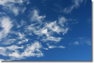
Altostratus clouds form at mid to high-level altitudes
(between 2 and 7 km) and are created by a warm, stable air mass which causes
water vapor
to condense as it rise through the atmosphere. Usually altostratus clouds are
featureless sheets characterized by a uniform color.
In some cases, wind punching through the cloud formation may give it a waved
appearance, called altostratus undulatus. Altostratus clouds
are commonly seen with other cloud formations accompanying them.
Next Topic: Cirrocumulus Clouds
Weather Topic: What are Cirrostratus Clouds?
Home - Education - Cloud Types - Cirrostratus Clouds
 Next Topic: Cirrus Clouds
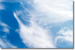
Cirrostratus clouds are high, thin clouds that form above
20,000 feet and are made mostly of ice crystals. They sometimes look like giant
feathers, horse tails, or curls of hair in the sky.
These clouds are pushed by the jet stream and can move at high speeds reaching
100 mph.
What do they indicate?
They indicate that a precipitation is likely within 24 hours.
Next Topic: Cirrus Clouds
Current conditions powered by WeatherAPI.com


