Weather Alert in Florida
Special Weather Statement issued August 23 at 12:01PM EDT by NWS Miami FL
AREAS AFFECTED: Hendry; Inland Palm Beach County; Inland Collier County; Inland Broward County
DESCRIPTION: At 1201 PM EDT, National Weather Service meteorologists were tracking a strong thunderstorm 8 miles south of Big Cypress Seminole Reservation, or 28 miles east of Ave Maria, moving northeast at 25 mph. HAZARD...Wind gusts of 45 to 50 mph. SOURCE...Radar indicated. IMPACT...Gusty winds could knock down tree limbs and blow around unsecured objects. Locations impacted include... Belle Glade, South Bay, Lake Harbor, Okeelanta, Holey Land Wildlife Refuge, Big Cypress Seminole Reservation, Rotenberger Wildlife Refuge, Miccosukee Indian Reservation, Belle Glade Camp, Miccosukee Service Plaza, Big Cypress National Preserve, and West Broward Rec. Area On Alligator Alley.
INSTRUCTION: These winds can down small tree limbs and branches, and blow around unsecured small objects. Seek shelter in a safe building until the storm passes.
Want more detail? Get the Complete 7 Day and Night Detailed Forecast!
Current U.S. National Radar--Current
The Current National Weather Radar is shown below with a UTC Time (subtract 5 hours from UTC to get Eastern Time).

National Weather Forecast--Current
The Current National Weather Forecast and National Weather Map are shown below.

National Weather Forecast for Tomorrow
Tomorrow National Weather Forecast and Tomorrow National Weather Map are show below.

North America Water Vapor (Moisture)
This map shows recent moisture content over North America. Bright and colored areas show high moisture (ie, clouds); brown indicates very little moisture present; black indicates no moisture.

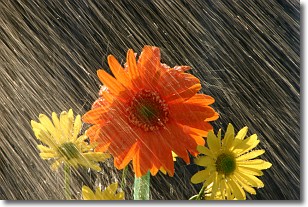
Weather Topic: What is Rain?
Home - Education - Precipitation - Rain
 Next Topic: Shelf Clouds
Precipitation in the form of water droplets is called rain.
Rain generally has a tendency to fall with less intensity over a greater period
of time, and when rainfall is more severe it is usually less sustained.
Rain is the most common form of precipitation and happens with greater frequency
depending on the season and regional influences. Cities have been shown to have
an observable effect on rainfall, due to an effect called the urban heat island.
Compared to upwind, monthly rainfall between twenty and forty miles downwind of
cities is 30% greater.
Next Topic: Shelf Clouds
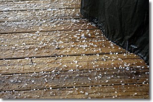
Weather Topic: What is Sleet?
Home - Education - Precipitation - Sleet
 Next Topic: Snow
Sleet is a form of precipitation in which small ice pellets are the primary
components. These ice pellets are smaller and more translucent than hailstones,
and harder than graupel. Sleet is caused by specific atmospheric conditions and
therefore typically doesn't last for extended periods of time.
The condition which leads to sleet formation requires a warmer body of air to be
wedged in between two sub-freezing bodies of air. When snow falls through a warmer
layer of air it melts, and as it falls through the next sub-freezing body of air
it freezes again, forming ice pellets known as sleet. In some cases, water
droplets don't have time to freeze before reaching the surface and the result is
freezing rain.
Next Topic: Snow
Current conditions powered by WeatherAPI.com


