Weather Alert in Louisiana
Red Flag Warning issued February 23 at 9:53AM CST until February 23 at 6:00PM CST by NWS Lake Charles LA
AREAS AFFECTED: Allen; Evangeline; St. Landry; Lafayette; Upper St. Martin; Lower St. Martin; West Cameron; East Cameron; Northern Calcasieu; Northern Jefferson Davis; Northern Acadia; Upper Vermilion; Upper Iberia; Upper St. Mary; Southern Calcasieu; Southern Jefferson Davis; Southern Acadia; Lower Vermilion; Lower Iberia; Lower St. Mary; Upper Jefferson; Northern Orange; Lower Jefferson; Southern Orange
DESCRIPTION: ...Fire weather warning in effect for (Today) Monday... The National Weather Service in Lake Charles has issued a Red Flag Warning for low humidity, which is in effect until 6 PM CST this evening. * AFFECTED AREA...Fire Weather Zone 031 Allen, Fire Weather Zone 032 Evangeline, Fire Weather Zone 033 St. Landry, Fire Weather Zone 044 Lafayette, Fire Weather Zone 045 Upper St. Martin, Fire Weather Zone 055 Lower St. Martin, Fire Weather Zone 073 West Cameron, Fire Weather Zone 074 East Cameron, Fire Weather Zone 141 Northern Calcasieu, Fire Weather Zone 142 Northern Jefferson Davis, Fire Weather Zone 143 Northern Acadia, Fire Weather Zone 152 Upper Vermilion, Fire Weather Zone 153 Upper Iberia, Fire Weather Zone 154 Upper St. Mary, Fire Weather Zone 241 Southern Calcasieu, Fire Weather Zone 242 Southern Jefferson Davis, Fire Weather Zone 243 Southern Acadia, Fire Weather Zone 252 Lower Vermilion, Fire Weather Zone 253 Lower Iberia, Fire Weather Zone 254 Lower St. Mary, Fire Weather Zone 515 Upper Jefferson, Fire Weather Zone 516 Northern Orange, Fire Weather Zone 615 Lower Jefferson and Fire Weather Zone 616 Southern Orange. * TIMING...Until 6 PM CST this evening. * WINDS...North 10 to 15 mph with gusts up to 25 mph. * RELATIVE HUMIDITY...As low as 10 percent. * TEMPERATURES...Up to 62. * IMPACTS...Any fire that develops will catch and spread quickly. Outdoor burning is not recommended.
INSTRUCTION: A Red Flag Warning means that critical fire weather conditions are either occurring now, or will shortly. A combination of strong winds, low relative humidity, and warm temperatures can contribute to extreme fire behavior.
Want more detail? Get the Complete 7 Day and Night Detailed Forecast!
Current U.S. National Radar--Current
The Current National Weather Radar is shown below with a UTC Time (subtract 5 hours from UTC to get Eastern Time).

National Weather Forecast--Current
The Current National Weather Forecast and National Weather Map are shown below.

National Weather Forecast for Tomorrow
Tomorrow National Weather Forecast and Tomorrow National Weather Map are show below.

North America Water Vapor (Moisture)
This map shows recent moisture content over North America. Bright and colored areas show high moisture (ie, clouds); brown indicates very little moisture present; black indicates no moisture.

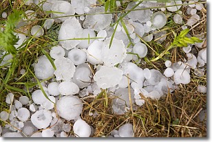
Weather Topic: What is Hail?
Home - Education - Precipitation - Hail
 Next Topic: Hole Punch Clouds
Hail is a form of precipitation which is recognized by large solid balls or
clumps of ice. Hail is created by thunderstorm clouds with strong updrafts of wind.
As the hailstones remain in the updraft, ice is deposited onto them until their
weight becomes heavy enough for them to fall to the earth's surface.
Hail storms can cause significant damage to crops, aircrafts, and man-made structures,
despite the fact that the duration is usually less than ten minutes.
Next Topic: Hole Punch Clouds
Weather Topic: What are Mammatus Clouds?
Home - Education - Cloud Types - Mammatus Clouds
 Next Topic: Nimbostratus Clouds
A mammatus cloud is a cloud with a unique feature which resembles
a web of pouches hanging along the base of the cloud.
In the United States, mammatus clouds tend to form in the warmer months, commonly
in the Midwest and eastern regions.
While they usually form at the bottom of a cumulonimbis cloud, they can also form
under altostratus, altocumulus, stratocumulus, and cirrus clouds. Mammatus clouds
warn that severe weather is close.
Next Topic: Nimbostratus Clouds
Current conditions powered by WeatherAPI.com


