Weather Alert in New Mexico
Flood Watch issued September 11 at 7:09PM MDT until September 13 at 12:00AM MDT by NWS Albuquerque NM
AREAS AFFECTED: Northwest Plateau; Far Northwest Highlands; Northwest Highlands; West Central Mountains; West Central Highlands; Tusas Mountains Including Chama; Jemez Mountains; Glorieta Mesa Including Glorieta Pass; Northern Sangre de Cristo Mountains; Southern Sangre de Cristo Mountains; East Slopes Sangre de Cristo Mountains; Upper Rio Grande Valley; Espanola Valley; Santa Fe Metro Area; Middle Rio Grande Valley/Albuquerque Metro Area; Sandia/Manzano Mountains Including Edgewood
DESCRIPTION: * WHAT...Flash flooding caused by excessive rainfall continues to be possible. * WHERE...Portions of northwestern, north-central, and central NM to include Farmington, Grants, Albuquerque, Santa Fe, Los Alamos, and Taos. * WHEN...From Friday morning through Friday evening. * IMPACTS...Excessive runoff may result in flooding of rivers, creeks, streams, and other low-lying and flood-prone locations. * ADDITIONAL DETAILS... - A disturbance ahead of a Pacific cold front will create training storms along northwest, west-central, central, and north-central New Mexico. Multiple rounds of thunderstorms will have potential to produce up to 2 inches of rainfall. Strong thunderstorms will create locally heavy rainfall rates of 1 to 2 inches per hour. Storms look to persist for several hours, particularly late into the evening hours on Friday along the middle Rio Grande Valley and the north-central mountains. - http://www.weather.gov/safety/flood
INSTRUCTION: You should monitor later forecasts and be prepared to take action should Flash Flood Warnings be issued. Turn around, don't drown when encountering flooded roads. Most flood deaths occur in vehicles.
Want more detail? Get the Complete 7 Day and Night Detailed Forecast!
Current U.S. National Radar--Current
The Current National Weather Radar is shown below with a UTC Time (subtract 5 hours from UTC to get Eastern Time).

National Weather Forecast--Current
The Current National Weather Forecast and National Weather Map are shown below.

National Weather Forecast for Tomorrow
Tomorrow National Weather Forecast and Tomorrow National Weather Map are show below.

North America Water Vapor (Moisture)
This map shows recent moisture content over North America. Bright and colored areas show high moisture (ie, clouds); brown indicates very little moisture present; black indicates no moisture.

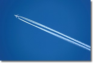
Weather Topic: What are Contrails?
Home - Education - Cloud Types - Contrails
 Next Topic: Cumulonimbus Clouds
A contrail is an artificial cloud, created by the passing of an
aircraft.
Contrails form because water vapor in the exhaust of aircraft engines is suspended
in the air under certain temperatures and humidity conditions. These contrails
are called exhaust contrails.
Another type of contrail can form due to a temporary reduction in air pressure
moving over the plane's surface, causing condensation.
These are called aerodynamic contrails.
When you can see your breath on a cold day, it is also because of condensation.
The reason contrails last longer than the condensation from your breath is
because the water in contrails freezes into ice particles.
Next Topic: Cumulonimbus Clouds
Weather Topic: What are Cumulus Clouds?
Home - Education - Cloud Types - Cumulus Clouds
 Next Topic: Drizzle
Cumulus clouds are fluffy and textured with rounded tops, and
may have flat bottoms. The border of a cumulus cloud
is clearly defined, and can have the appearance of cotton or cauliflower.
Cumulus clouds form at low altitudes (rarely above 2 km) but can grow very tall,
becoming cumulus congestus and possibly the even taller cumulonimbus clouds.
When cumulus clouds become taller, they have a greater chance of producing precipitation.
Next Topic: Drizzle
Current conditions powered by WeatherAPI.com


