Weather Alert in Alaska
Winter Weather Advisory issued February 22 at 1:47PM AKST until February 24 at 4:00PM AKST by NWS Anchorage AK
AREAS AFFECTED: Central Copper Valley; Tok Cutoff
DESCRIPTION: * WHAT...Snow expected. Total snow accumulations between 3 and 7 inches for the Glennallen area and 6 to 13 inches along the Tok Cutoff. * WHERE...Central Copper Valley and Tok Cutoff, including Glennallen, Gakona, Chistochina, and Slana. * WHEN...From noon Monday to 4 PM AKST Tuesday. * IMPACTS...Travel could be very difficult. Visibility reduced to one half mile or less at times. * ADDITIONAL DETAILS...Steady light snow will develop early Monday afternoon and quickly intensify through the afternoon hours. The heaviest snow is expected along the Tok Cutoff from around Chistochina to Slana Monday afternoon through Monday night. Snow will gradually taper off during the day Tuesday. However, gusty northwest to northeast winds will develop and lead to reduced visibilities as the freshly fallen snow is lofted and blown around. The gusty winds and blowing snow will likely continue through Tuesday night.
INSTRUCTION: Slow down and use caution while traveling. For the latest road conditions call 5 1 1 or visit 511.alaska.gov.
Want more detail? Get the Complete 7 Day and Night Detailed Forecast!
Current U.S. National Radar--Current
The Current National Weather Radar is shown below with a UTC Time (subtract 5 hours from UTC to get Eastern Time).

National Weather Forecast--Current
The Current National Weather Forecast and National Weather Map are shown below.

National Weather Forecast for Tomorrow
Tomorrow National Weather Forecast and Tomorrow National Weather Map are show below.

North America Water Vapor (Moisture)
This map shows recent moisture content over North America. Bright and colored areas show high moisture (ie, clouds); brown indicates very little moisture present; black indicates no moisture.

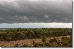
Weather Topic: What are Shelf Clouds?
Home - Education - Cloud Types - Shelf Clouds
 Next Topic: Sleet
A shelf cloud is similar to a wall cloud, but forms at the front
of a storm cloud, instead of at the rear, where wall clouds form.
A shelf cloud is caused by a series of events set into motion by the advancing
storm; first, cool air settles along the ground where precipitation has just fallen.
As the cool air is brought in, the warmer air is displaced, and rises above it,
because it is less dense. When the warmer air reaches the bottom of the storm cloud,
it begins to cool again, and the resulting condensation is a visible shelf cloud.
Next Topic: Sleet
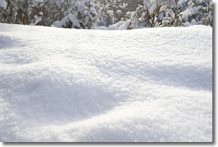
Weather Topic: What is Snow?
Home - Education - Precipitation - Snow
 Next Topic: Stratocumulus Clouds
Snow is precipitation taking the form of ice crystals. Each ice crystal, or snowflake,
has unique characteristics, but all of them grow in a hexagonal structure.
Snowfall can last for sustained periods of time and result in significant buildup
of snow on the ground.
On the earth's surface, snow starts out light and powdery, but as it begins to melt
it tends to become more granular, producing small bits of ice which have the consistency of
sand. After several cycles of melting and freezing, snow can become very dense
and ice-like, commonly known as snow pack.
Next Topic: Stratocumulus Clouds
Current conditions powered by WeatherAPI.com


