Weather Alert in California
Fire Weather Watch issued June 11 at 11:20AM PDT until June 14 at 11:00PM PDT by NWS Reno NV
AREAS AFFECTED: Surprise Valley California; Eastern Lassen County; Northern Washoe County
DESCRIPTION: The National Weather Service in Reno has issued a Fire Weather Watch for gusty winds and low humidity, which is in effect from Friday morning through Saturday evening. * Affected Area...Fire Weather Zone 270 Surprise Valley California, Fire Weather Zone 278 Eastern Lassen County and Fire Weather Zone 458 Northern Washoe County. * Winds...Southwest to west 15-25 mph with gusts to 35 mph. * Humidity...Minimum afternoon humidity 10-18% Friday and 7-14% Saturday. Limited humidity recovery to 30-50% Friday night. * Duration...3 to 6 hours each afternoon Friday and Saturday. * Impacts...The combination of gusty winds and low humidity can cause fire to rapidly grow in size and intensity before first responders can contain them. These dry and windy conditions could also rekindle fires in areas which received lightning in recent days. * Additional Details...Dry conditions and shorter periods of gusty winds will also produce elevated to locally critical fire weather conditions each afternoon today and Thursday.
INSTRUCTION: Avoid outdoor activities that can cause a spark near dry vegetation, such as yard work, target shooting, or campfires. Follow local fire restrictions. Check weather.gov/reno for updates and livingwithfire.info for preparedness tips.
Want more detail? Get the Complete 7 Day and Night Detailed Forecast!
Current U.S. National Radar--Current
The Current National Weather Radar is shown below with a UTC Time (subtract 5 hours from UTC to get Eastern Time).

National Weather Forecast--Current
The Current National Weather Forecast and National Weather Map are shown below.

National Weather Forecast for Tomorrow
Tomorrow National Weather Forecast and Tomorrow National Weather Map are show below.

North America Water Vapor (Moisture)
This map shows recent moisture content over North America. Bright and colored areas show high moisture (ie, clouds); brown indicates very little moisture present; black indicates no moisture.

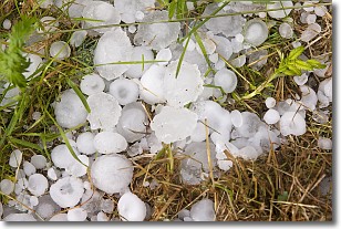
Weather Topic: What is Hail?
Home - Education - Precipitation - Hail
 Next Topic: Hole Punch Clouds
Hail is a form of precipitation which is recognized by large solid balls or
clumps of ice. Hail is created by thunderstorm clouds with strong updrafts of wind.
As the hailstones remain in the updraft, ice is deposited onto them until their
weight becomes heavy enough for them to fall to the earth's surface.
Hail storms can cause significant damage to crops, aircrafts, and man-made structures,
despite the fact that the duration is usually less than ten minutes.
Next Topic: Hole Punch Clouds
Weather Topic: What are Mammatus Clouds?
Home - Education - Cloud Types - Mammatus Clouds
 Next Topic: Nimbostratus Clouds
A mammatus cloud is a cloud with a unique feature which resembles
a web of pouches hanging along the base of the cloud.
In the United States, mammatus clouds tend to form in the warmer months, commonly
in the Midwest and eastern regions.
While they usually form at the bottom of a cumulonimbis cloud, they can also form
under altostratus, altocumulus, stratocumulus, and cirrus clouds. Mammatus clouds
warn that severe weather is close.
Next Topic: Nimbostratus Clouds
Current conditions powered by WeatherAPI.com


