Weather Alert in California
Severe Thunderstorm Warning issued August 25 at 2:28PM PDT until August 25 at 3:30PM PDT by NWS San Diego CA
AREAS AFFECTED: Riverside, CA
DESCRIPTION: SVRSGX The National Weather Service in San Diego has issued a * Severe Thunderstorm Warning for... Riverside County in southern California... * Until 330 PM PDT. * At 228 PM PDT, a severe thunderstorm was located near Palm Springs, moving east at 20 mph. HAZARD...60 mph wind gusts. SOURCE...Radar indicated. IMPACT...Expect damage to roofs, siding, and trees. * Locations impacted include... Palm Springs, Mt San Jacinto State Park, Idyllwild-Pine Cove, Hwy 243 Between Banning And Idyllwild, Cathedral City, Palm Desert, southeastern Desert Hot Springs, Rancho Mirage, Mountain Center, North Palm Springs, Hwy 74 Between Hemet And Mountain Center, Hwy 74 Between Mountain Center And Anza, Whitewater, Indian Wells, Lake Hemet, Sky Valley, and Thousand Palms.
INSTRUCTION: For your protection move to an interior room on the lowest floor of a building. Large hail, damaging wind, and continuous cloud to ground lightning are occurring with this storm. Move indoors immediately. Lightning is one of nature's leading killers. Remember, if you can hear thunder, you are close enough to be struck by lightning.
Want more detail? Get the Complete 7 Day and Night Detailed Forecast!
Current U.S. National Radar--Current
The Current National Weather Radar is shown below with a UTC Time (subtract 5 hours from UTC to get Eastern Time).

National Weather Forecast--Current
The Current National Weather Forecast and National Weather Map are shown below.

National Weather Forecast for Tomorrow
Tomorrow National Weather Forecast and Tomorrow National Weather Map are show below.

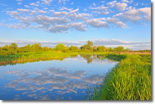
North America Water Vapor (Moisture)
This map shows recent moisture content over North America. Bright and colored areas show high moisture (ie, clouds); brown indicates very little moisture present; black indicates no moisture.

Weather Topic: What are Stratocumulus Clouds?
Home - Education - Cloud Types - Stratocumulus Clouds
 Next Topic: Stratus Clouds
Stratocumulus clouds are similar to altocumulus clouds in their
fluffy appearance, but have a slightly darker shade due to their additional mass.
A good way to distinguish the two cloud types is to hold your hand out and measure
the size of an individual cloud; if it is the size of your thumb it is generally
an altocumulus cloud, if it is the size of your hand it is generally a
stratocumulus cloud.
It is uncommon for stratocumulus clouds to produce precipitation, but if they do
it is usually a light rain or snow.
Next Topic: Stratus Clouds
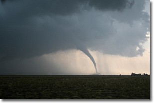
Weather Topic: What are Wall Clouds?
Home - Education - Cloud Types - Wall Clouds
 Next Topic: Altocumulus Clouds
A wall cloud forms underneath the base of a cumulonimbus cloud,
and can be a hotbed for deadly tornadoes.
Wall clouds are formed by air flowing into the cumulonimbus clouds, which can
result in the wall cloud descending from the base of the cumulonimbus cloud, or
rising fractus clouds which join to the base of the storm cloud as the wall cloud
takes shape.
Wall clouds can be very large, and in the Northern Hemisphere they generally
form at the southern edge of cumulonimbus clouds.
Next Topic: Altocumulus Clouds
Current conditions powered by WeatherAPI.com


