Weather Alert in New Mexico
Red Flag Warning issued March 5 at 6:59PM MST until March 6 at 6:00PM MST by NWS Albuquerque NM
AREAS AFFECTED: Northeast Plains; Northeast Highlands; Central Highlands; East Central Plains
DESCRIPTION: ...RED FLAG WARNING FRIDAY FROM 10 AM UNTIL 6 PM MST EAST OF THE CENTRAL MOUNTAIN CHAIN DUE TO STRONG WIND AND LOW HUMIDITY... .Red Flag conditions are ending this evening, but will return on Friday. Winds will increase again as a weather disturbance and Pacific trough move through. Southwest wind gusts of 40 to 50 mph will be common across eastern New Mexico on Friday along with low humidity in the single digits to low teens. * AREA AND TIMING...This includes the Northeast Plains (Zone 104), Northeast Highlands (Zone 123), East-Central Plains (Zone 126), and Central Highlands (Zone 125) from 10 AM MST to 6 PM MST Friday. * 20 FOOT WINDS...West and northwest winds 25 to 35 mph with gusts up to 50 mph on Friday. * RELATIVE HUMIDITY...Minimum values between 7 to 16 percent on Friday. * IMPACTS...Any fires that develop will likely spread rapidly. Outdoor burning is not recommended.
INSTRUCTION: Please advise the appropriate officials or fire crews in the field of this Red Flag Warning.
Want more detail? Get the Complete 7 Day and Night Detailed Forecast!
Current U.S. National Radar--Current
The Current National Weather Radar is shown below with a UTC Time (subtract 5 hours from UTC to get Eastern Time).

National Weather Forecast--Current
The Current National Weather Forecast and National Weather Map are shown below.

National Weather Forecast for Tomorrow
Tomorrow National Weather Forecast and Tomorrow National Weather Map are show below.

North America Water Vapor (Moisture)
This map shows recent moisture content over North America. Bright and colored areas show high moisture (ie, clouds); brown indicates very little moisture present; black indicates no moisture.

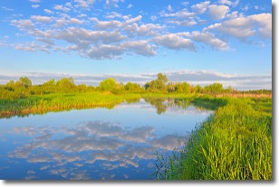
Weather Topic: What are Stratocumulus Clouds?
Home - Education - Cloud Types - Stratocumulus Clouds
 Next Topic: Stratus Clouds
Stratocumulus clouds are similar to altocumulus clouds in their
fluffy appearance, but have a slightly darker shade due to their additional mass.
A good way to distinguish the two cloud types is to hold your hand out and measure
the size of an individual cloud; if it is the size of your thumb it is generally
an altocumulus cloud, if it is the size of your hand it is generally a
stratocumulus cloud.
It is uncommon for stratocumulus clouds to produce precipitation, but if they do
it is usually a light rain or snow.
Next Topic: Stratus Clouds
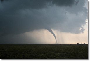
Weather Topic: What are Wall Clouds?
Home - Education - Cloud Types - Wall Clouds
 Next Topic: Altocumulus Clouds
A wall cloud forms underneath the base of a cumulonimbus cloud,
and can be a hotbed for deadly tornadoes.
Wall clouds are formed by air flowing into the cumulonimbus clouds, which can
result in the wall cloud descending from the base of the cumulonimbus cloud, or
rising fractus clouds which join to the base of the storm cloud as the wall cloud
takes shape.
Wall clouds can be very large, and in the Northern Hemisphere they generally
form at the southern edge of cumulonimbus clouds.
Next Topic: Altocumulus Clouds
Current conditions powered by WeatherAPI.com


