Weather Alert in Kansas
Severe Thunderstorm Warning issued September 3 at 7:10PM CDT until September 3 at 8:15PM CDT by NWS Wichita KS
AREAS AFFECTED: Sedgwick, KS
DESCRIPTION: SVRICT The National Weather Service in Wichita has issued a * Severe Thunderstorm Warning for... Sedgwick County in south central Kansas... * Until 815 PM CDT. * At 709 PM CDT, a severe thunderstorm was located over Bentley, or near Sedgwick, moving south at 35 mph. HAZARD...Tennis ball size hail and 70 mph wind gusts. SOURCE...Radar indicated. IMPACT...People and animals outdoors will be injured. Expect hail damage to roofs, siding, windows, and vehicles. Expect considerable tree damage. Wind damage is also likely to mobile homes, roofs, and outbuildings. * Locations impacted include... Wichita, Derby, Andover, Haysville, Park City, Valley Center, Bel Aire, Mulvane, Goddard, Rose Hill, Maize, Clearwater, Sedgwick, Colwich, Garden Plain, Mount Hope, Downtown Wichita, Kechi, Andale, and Eastborough. This includes the following highways... Interstate 135 between Mile Markers 0 and 22. Interstate 35 between Mile Markers 34 and 54.
INSTRUCTION: For your protection move to an interior room on the lowest floor of a building.
Want more detail? Get the Complete 7 Day and Night Detailed Forecast!
Current U.S. National Radar--Current
The Current National Weather Radar is shown below with a UTC Time (subtract 5 hours from UTC to get Eastern Time).

National Weather Forecast--Current
The Current National Weather Forecast and National Weather Map are shown below.

National Weather Forecast for Tomorrow
Tomorrow National Weather Forecast and Tomorrow National Weather Map are show below.

North America Water Vapor (Moisture)
This map shows recent moisture content over North America. Bright and colored areas show high moisture (ie, clouds); brown indicates very little moisture present; black indicates no moisture.

Weather Topic: What is Freezing Rain?
Home - Education - Precipitation - Freezing Rain
 Next Topic: Graupel
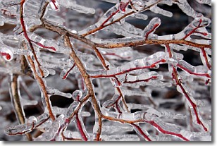
Freezing rain is a condition where precipitation which has fallen in the form of
water droplets reaches temperatures which are below freezing and freezes upon
coming into contact
with surface objects. The result of this precipitation is a glaze of ice which
can be damaging to plants and man-made structures. A severe onset of freezing
rain which results in a very thick glaze of ice is known as an ice storm.
Next Topic: Graupel
Weather Topic: What is Hail?
Home - Education - Precipitation - Hail
 Next Topic: Hole Punch Clouds
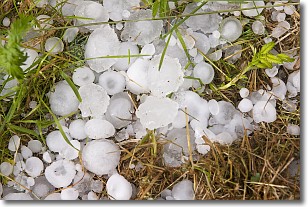
Hail is a form of precipitation which is recognized by large solid balls or
clumps of ice. Hail is created by thunderstorm clouds with strong updrafts of wind.
As the hailstones remain in the updraft, ice is deposited onto them until their
weight becomes heavy enough for them to fall to the earth's surface.
Hail storms can cause significant damage to crops, aircrafts, and man-made structures,
despite the fact that the duration is usually less than ten minutes.
Next Topic: Hole Punch Clouds
Current conditions powered by WeatherAPI.com


