Weather Alert in Montana
Avalanche Warning issued February 23 at 7:09AM MST by NWS Missoula MT
AREAS AFFECTED: Kootenai/Cabinet Region; West Glacier Region
DESCRIPTION: AVWMSO The following message is transmitted at the request of Flathead Avalanche Center Hungry Horse MT. ...AVALANCHE WARNING ISSUED BY THE FLATHEAD AVALANCHE CENTER... 06:30 MST Mon Feb 23 2026 The Flathead Avalanche Center in Hungry Horse has issued a BACKCOUNTRY AVALANCHE WARNING for the following areas: NWS Missoula MT - MTZ001 (MTZ001)...MTZ002 (MTZ002) * WHAT...Heavy snowfall rates and wind-drifted snow will create very dangerous avalanche conditions. * WHERE...Slopes above 5000 feet in the Whitefish, Swan and Flathead Ranges, and the Lake McDonald and Marias Pass areas of Glacier National Park.</p> * WHEN...In effect from Mon 06:30 MST to Tue 06:01 MST. * IMPACTS...Natural and human-triggered avalanches are very likely. Avalanches will release on weak layers buried 2 to 3+ feet deep. These will run long distances, travel into low-angle terrain, and can cover snowmobile trails. Avalanches may connect across terrain features like ridges, releasing multiple start zones at once. Avalanches can be triggered from long distances away. Smaller slopes, such as roadcuts, may also avalanche, depositing a surprising amount of debris on the road below. * PRECAUTIONARY / PREPAREDNESS ACTIONS...Very dangerous avalanche conditions. Pay close attention to the terrain around you. Avoid traveling on and under steep slopes. Consult http://www.flatheadavalanche.org/ or www.avalanche.org for more detailed information. Similar avalanche danger may exist at locations outside the coverage area of this or any avalanche center.
INSTRUCTION: N/A
Want more detail? Get the Complete 7 Day and Night Detailed Forecast!
Current U.S. National Radar--Current
The Current National Weather Radar is shown below with a UTC Time (subtract 5 hours from UTC to get Eastern Time).

National Weather Forecast--Current
The Current National Weather Forecast and National Weather Map are shown below.

National Weather Forecast for Tomorrow
Tomorrow National Weather Forecast and Tomorrow National Weather Map are show below.

North America Water Vapor (Moisture)
This map shows recent moisture content over North America. Bright and colored areas show high moisture (ie, clouds); brown indicates very little moisture present; black indicates no moisture.

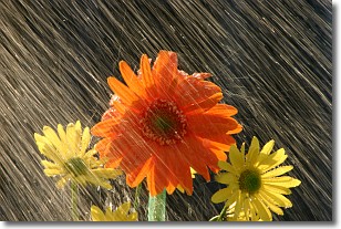
Weather Topic: What is Precipitation?
Home - Education - Precipitation - Precipitation
 Next Topic: Rain
Precipitation can refer to many different forms of water that
may fall from clouds. Precipitation occurs after a cloud has become saturated to
the point where its water particles are more dense than the air below the cloud.
In most cases, precipitation will reach the ground, but it is not uncommon for
precipitation to evaporate before it reaches the earth's surface.
When precipitation evaporates before it contacts the ground it is called Virga.
Graupel, hail, sleet, rain, drizzle, and snow are forms of precipitation, but fog
and mist are not considered precipitation because the water vapor which
constitutes them isn't dense enough to fall to the ground.
Next Topic: Rain
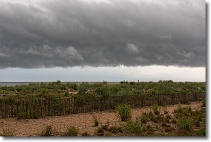
Weather Topic: What are Shelf Clouds?
Home - Education - Cloud Types - Shelf Clouds
 Next Topic: Sleet
A shelf cloud is similar to a wall cloud, but forms at the front
of a storm cloud, instead of at the rear, where wall clouds form.
A shelf cloud is caused by a series of events set into motion by the advancing
storm; first, cool air settles along the ground where precipitation has just fallen.
As the cool air is brought in, the warmer air is displaced, and rises above it,
because it is less dense. When the warmer air reaches the bottom of the storm cloud,
it begins to cool again, and the resulting condensation is a visible shelf cloud.
Next Topic: Sleet
Current conditions powered by WeatherAPI.com


