Weather Alert in Illinois
Flood Watch issued July 26 at 4:22AM CDT until July 26 at 7:00PM CDT by NWS Chicago IL
AREAS AFFECTED: Ogle; Lee; De Kalb; Kane; DuPage; La Salle; Kendall; Grundy; Northern Cook; Central Cook; Southern Cook; Northern Will; Southern Will; Eastern Will; Lake
DESCRIPTION: * WHAT...Flash flooding caused by excessive rainfall continues to be possible. * WHERE...Portions of Illinois, including the following areas, Cook, De Kalb, DuPage, Will, Grundy, Kane, Kendall, La Salle, Lee, Ogle,and northwest Indiana, including the following area, Lake IN. * WHEN...Through this evening. * IMPACTS...Creeks and streams may rise out of their banks. Flooding may occur in poor drainage and urban areas. Underpasses may be flooded. Roads and streets may be flooded. Storm drains and ditches may be clogged with debris, increasing the risk of flooding. Additionally, flooding of basements may occur if thunderstorms train over urban areas. * ADDITIONAL DETAILS... - Additional waves of showers and thunderstorms will move into northeast Illinois, including over areas that experienced several inches of rain yesterday. The tropical-like airmass will support rain rates in excess of 2 inches per hour in the strongest thunderstorms, leading to a threat for flash flooding. - http://www.weather.gov/safety/flood
INSTRUCTION: Monitor the latest forecasts and be prepared to take quick action should flooding develop.
Want more detail? Get the Complete 7 Day and Night Detailed Forecast!
Current U.S. National Radar--Current
The Current National Weather Radar is shown below with a UTC Time (subtract 5 hours from UTC to get Eastern Time).

National Weather Forecast--Current
The Current National Weather Forecast and National Weather Map are shown below.

National Weather Forecast for Tomorrow
Tomorrow National Weather Forecast and Tomorrow National Weather Map are show below.

North America Water Vapor (Moisture)
This map shows recent moisture content over North America. Bright and colored areas show high moisture (ie, clouds); brown indicates very little moisture present; black indicates no moisture.

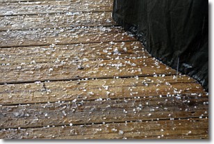
Weather Topic: What is Sleet?
Home - Education - Precipitation - Sleet
 Next Topic: Snow
Sleet is a form of precipitation in which small ice pellets are the primary
components. These ice pellets are smaller and more translucent than hailstones,
and harder than graupel. Sleet is caused by specific atmospheric conditions and
therefore typically doesn't last for extended periods of time.
The condition which leads to sleet formation requires a warmer body of air to be
wedged in between two sub-freezing bodies of air. When snow falls through a warmer
layer of air it melts, and as it falls through the next sub-freezing body of air
it freezes again, forming ice pellets known as sleet. In some cases, water
droplets don't have time to freeze before reaching the surface and the result is
freezing rain.
Next Topic: Snow
Weather Topic: What are Stratocumulus Clouds?
Home - Education - Cloud Types - Stratocumulus Clouds
 Next Topic: Stratus Clouds
Stratocumulus clouds are similar to altocumulus clouds in their
fluffy appearance, but have a slightly darker shade due to their additional mass.
A good way to distinguish the two cloud types is to hold your hand out and measure
the size of an individual cloud; if it is the size of your thumb it is generally
an altocumulus cloud, if it is the size of your hand it is generally a
stratocumulus cloud.
It is uncommon for stratocumulus clouds to produce precipitation, but if they do
it is usually a light rain or snow.
Next Topic: Stratus Clouds
Current conditions powered by WeatherAPI.com


