Weather Alert in Pennsylvania
Severe Thunderstorm Warning issued March 31 at 6:12PM EDT until March 31 at 7:15PM EDT by NWS Pittsburgh PA
AREAS AFFECTED: Mercer, PA
DESCRIPTION: SVRPBZ The National Weather Service in Pittsburgh has issued a * Severe Thunderstorm Warning for... Mercer County in northwestern Pennsylvania... * Until 715 PM EDT. * At 612 PM EDT, severe thunderstorms were located along a line from 29 miles northwest of Greenville to 30 miles north of Salem, or along a line from 34 miles northwest of Sharpsville to 27 miles west of Sharon, moving east at 65 mph. HAZARD...70 mph wind gusts and small hail. SOURCE...Radar indicated. IMPACT...Expect considerable tree damage. Damage is likely to mobile homes, roofs, and outbuildings. * Locations impacted include... Hermitage, Sharpsville, Greenville, Stoneboro, Sandy Lake, Clark, Jamestown, Fredonia, Jackson Center, New Lebanon, Sheakleyville and Maurice K Goddard State Park.
INSTRUCTION: Anyone outdoors should move to shelter inside a well-built structure and stay away from windows. These storms are capable of producing widespread damaging winds. Report severe weather to your nearest law enforcement agency or the National Weather Service office in Pittsburgh PA.
Want more detail? Get the Complete 7 Day and Night Detailed Forecast!
Current U.S. National Radar--Current
The Current National Weather Radar is shown below with a UTC Time (subtract 5 hours from UTC to get Eastern Time).

National Weather Forecast--Current
The Current National Weather Forecast and National Weather Map are shown below.

National Weather Forecast for Tomorrow
Tomorrow National Weather Forecast and Tomorrow National Weather Map are show below.

North America Water Vapor (Moisture)
This map shows recent moisture content over North America. Bright and colored areas show high moisture (ie, clouds); brown indicates very little moisture present; black indicates no moisture.

Weather Topic: What is Sleet?
Home - Education - Precipitation - Sleet
 Next Topic: Snow
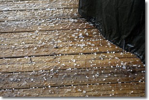
Sleet is a form of precipitation in which small ice pellets are the primary
components. These ice pellets are smaller and more translucent than hailstones,
and harder than graupel. Sleet is caused by specific atmospheric conditions and
therefore typically doesn't last for extended periods of time.
The condition which leads to sleet formation requires a warmer body of air to be
wedged in between two sub-freezing bodies of air. When snow falls through a warmer
layer of air it melts, and as it falls through the next sub-freezing body of air
it freezes again, forming ice pellets known as sleet. In some cases, water
droplets don't have time to freeze before reaching the surface and the result is
freezing rain.
Next Topic: Snow
Weather Topic: What are Stratocumulus Clouds?
Home - Education - Cloud Types - Stratocumulus Clouds
 Next Topic: Stratus Clouds
Stratocumulus clouds are similar to altocumulus clouds in their
fluffy appearance, but have a slightly darker shade due to their additional mass.
A good way to distinguish the two cloud types is to hold your hand out and measure
the size of an individual cloud; if it is the size of your thumb it is generally
an altocumulus cloud, if it is the size of your hand it is generally a
stratocumulus cloud.
It is uncommon for stratocumulus clouds to produce precipitation, but if they do
it is usually a light rain or snow.
Next Topic: Stratus Clouds
Current conditions powered by WeatherAPI.com


