Weather Alert in Hawaii
High Surf Advisory issued February 22 at 3:02PM HST until February 24 at 6:00PM HST by NWS Honolulu HI
AREAS AFFECTED: Maui Leeward West; Kohala; Molokai West; Lanai Windward
DESCRIPTION: ...HIGH SURF WARNING FOR NORTH AND EAST FACING SHORES OF NIIHAU KAUAI OAHU MOLOKAI MAUI AND BIG ISLAND FROM NOON MONDAY THROUGH TUESDAY AFTERNOON... ...HIGH SURF ADVISORY FOR WEST FACING SHORES OF MOLOKAI MAUI AND BIG ISLAND AND FOR NORTH FACING SHORES OF LANAI MONDAY NIGHT THROUGH TUESDAY... .A long period north-northeast swell will build on Monday and peak Monday night and Tuesday. This large swell from 010 to 030 degrees will produce much larger than normal surf across some coastlines, especially in windward areas. The swell will gradually decline Tuesday night through Friday. * WHAT...Along west facing shores of the Big Island in the Kohala Districts, surf building to 6 to 10 feet Monday night and Tuesday. Along west facing shores of Maui, surf building to 8 to 15 feet Monday night and Tuesday. Along west facing shores of Molokai and north facing shores of Lanai, surf building to 10 to 16 feet Monday night and Tuesday. * WHERE...West facing shores of Molokai, Maui, and Big Island and for north facing shores of Lanai. * WHEN...From 6 PM Monday to 6 PM HST Tuesday. * IMPACTS...Moderate. Strong breaking waves and strong currents will make swimming dangerous.
INSTRUCTION: Heed all advice from ocean safety officials. When in doubt, don't go out.
Want more detail? Get the Complete 7 Day and Night Detailed Forecast!
Current U.S. National Radar--Current
The Current National Weather Radar is shown below with a UTC Time (subtract 5 hours from UTC to get Eastern Time).

National Weather Forecast--Current
The Current National Weather Forecast and National Weather Map are shown below.

National Weather Forecast for Tomorrow
Tomorrow National Weather Forecast and Tomorrow National Weather Map are show below.

North America Water Vapor (Moisture)
This map shows recent moisture content over North America. Bright and colored areas show high moisture (ie, clouds); brown indicates very little moisture present; black indicates no moisture.

Weather Topic: What are Altostratus Clouds?
Home - Education - Cloud Types - Altostratus Clouds
 Next Topic: Cirrocumulus Clouds
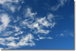
Altostratus clouds form at mid to high-level altitudes
(between 2 and 7 km) and are created by a warm, stable air mass which causes
water vapor
to condense as it rise through the atmosphere. Usually altostratus clouds are
featureless sheets characterized by a uniform color.
In some cases, wind punching through the cloud formation may give it a waved
appearance, called altostratus undulatus. Altostratus clouds
are commonly seen with other cloud formations accompanying them.
Next Topic: Cirrocumulus Clouds
Weather Topic: What are Cirrostratus Clouds?
Home - Education - Cloud Types - Cirrostratus Clouds
 Next Topic: Cirrus Clouds
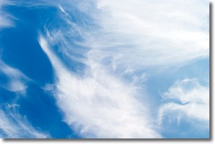
Cirrostratus clouds are high, thin clouds that form above
20,000 feet and are made mostly of ice crystals. They sometimes look like giant
feathers, horse tails, or curls of hair in the sky.
These clouds are pushed by the jet stream and can move at high speeds reaching
100 mph.
What do they indicate?
They indicate that a precipitation is likely within 24 hours.
Next Topic: Cirrus Clouds
Current conditions powered by WeatherAPI.com


