Weather Alert in Arizona
Flash Flood Warning issued September 4 at 12:40PM MST until September 4 at 3:45PM MST by NWS Flagstaff AZ
AREAS AFFECTED: Coconino, AZ
DESCRIPTION: FFWFGZ The National Weather Service in Flagstaff has issued a * Flash Flood Warning for...The South Canyon Wash Basin downstream of the Dragon Bravo Fire...in Coconino County in north central Arizona...this includes the Colorado River between river miles 32 and 48. * Until 345 PM MST /445 PM MDT/. * At 1240 PM MST /140 PM MDT/, Doppler radar indicated thunderstorms producing heavy rain over the South Canyon Wash Basin downstream of the Dragon Bravo Fire. Flash flooding is ongoing or expected to begin shortly. Excessive rainfall over the burn scar will result in debris flow moving through the South Canyon Wash and other washes downriver to river mile 48. The debris flow can consist of rock, mud, vegetation and other loose materials. HAZARD...Life threatening flash flooding. Thunderstorms producing flash flooding in and around the South Canyon Wash Basin downstream of the Dragon Bravo Fire. SOURCE...Radar indicated. IMPACT...Life threatening flash flooding of areas in and around the South Canyon Wash Basin downstream of the Dragon Bravo Fire. * Some locations that will experience flash flooding include... Grand Canyon National Park, Bert Loper's Boat, Royal Arches, Triple Alcoves, Point Hansbrough, Anasazi Foot Bridge and Saddle Mountain Wilderness. This includes the Colorado River between river miles 32 and 48. This includes the following recreation areas and campgrounds... South Canyon Camp Site, Below Redwall Camp Site, Little Redwall Camp Site, Nautiloid Camp Site, Tatahatso Wash Camp Site, Tatahatso Camp Site, Above Martha's Camp Site, Martha's Camp Site, Redbud Alcove Camp Site, MCD Site Camp Site, Upper Buck Farm Camp Site, Buck Farm Camp Site, Below Buck Farm Camp Site, Loper's Boat Camp Site, Royal Arches Camp Site, Anasazi Bridge Camp Site, Lower Anasazi Camp Site, President Harding Camp Site, Eminence Camp Site, Above Willie Taylor Camp Site, Willie Taylor Camp Site, Triple Alcoves Camp Site, Duck N Quack Camp Site, Upper Saddle Camp Site and Lower Saddle Camp Site. This includes the following creeks, washes and rivers... Saddle Canyon, Colorado River, Buck Farm Canyon, South Canyon, "Bert's Canyon", Nautiloid Canyon, Tatahoysa Wash, "Redbud Alcove" and Tatahatso Wash.
INSTRUCTION: This is a life threatening situation. Heavy rainfall will cause extensive and severe flash flooding of creeks...streams...and ditches in the South Canyon Wash Basin downstream of the Dragon Bravo Fire. Severe debris flows can also be anticipated across roads. Roads and driveways may be washed away in places. If you encounter flood waters...climb to safety.
Want more detail? Get the Complete 7 Day and Night Detailed Forecast!
Current U.S. National Radar--Current
The Current National Weather Radar is shown below with a UTC Time (subtract 5 hours from UTC to get Eastern Time).

National Weather Forecast--Current
The Current National Weather Forecast and National Weather Map are shown below.

National Weather Forecast for Tomorrow
Tomorrow National Weather Forecast and Tomorrow National Weather Map are show below.

North America Water Vapor (Moisture)
This map shows recent moisture content over North America. Bright and colored areas show high moisture (ie, clouds); brown indicates very little moisture present; black indicates no moisture.

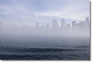
Weather Topic: What is Fog?
Home - Education - Cloud Types - Fog
 Next Topic: Fractus Clouds
Fog is technically a type of stratus cloud, which lies along the
ground and obscures visibility.
It is usually created when humidity in the air condenses into tiny water droplets.
Because of this, some places are more prone to foggy weather, such as regions
close to a body of water.
Fog is similar to mist; both are the appearance of water droplets suspended in
the air, but fog is the term applied to the condition when visibility is less than 1 km.
Next Topic: Fractus Clouds
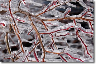
Weather Topic: What is Freezing Rain?
Home - Education - Precipitation - Freezing Rain
 Next Topic: Graupel
Freezing rain is a condition where precipitation which has fallen in the form of
water droplets reaches temperatures which are below freezing and freezes upon
coming into contact
with surface objects. The result of this precipitation is a glaze of ice which
can be damaging to plants and man-made structures. A severe onset of freezing
rain which results in a very thick glaze of ice is known as an ice storm.
Next Topic: Graupel
Current conditions powered by WeatherAPI.com


