Weather Alert in Washington
Flood Warning issued March 21 at 8:34PM PDT until March 22 at 1:40PM PDT by NWS Seattle WA
AREAS AFFECTED: Snohomish, WA
DESCRIPTION: ...The Flood Warning is extended for the following rivers in Washington... Snohomish River Near Monroe affecting Snohomish County. Snohomish River At Snohomish affecting Snohomish County. * WHAT...Moderate flooding is occurring, with the river slowly receding through Sunday. * WHERE...Snohomish River near Monroe. * WHEN...Until early tomorrow afternoon. * IMPACTS...At 16.0 feet, the Snohomish River will flood several roads and much of the low pasture land in the river valley. A stage of 16 feet at this location corresponds to Phase 2 in the Snohomish County Flood Warning System. * ADDITIONAL DETAILS... - At 8:15 PM PDT Saturday the stage was 16.3 feet. - Flood stage is 15.0 feet. - Recent Activity...The maximum river stage in the 24 hours ending at 8:15 PM PDT Saturday was 18.4 feet. - Forecast...The river is expected to fall below flood stage early Sunday morning, and continuing to recede to below 10.0 ft by late Sunday evening. - http://www.weather.gov/safety/flood
INSTRUCTION: Caution is urged when walking near riverbanks. Be especially cautious at night when it is harder to recognize the dangers of flooding. Turn around, don't drown when encountering flooded roads. Most flood deaths occur in vehicles. Motorists should not attempt to drive around barricades or drive cars through flooded areas. Additional information is available at www.weather.gov. The next statement will be issued by late tonight at 445 AM PDT.
Want more detail? Get the Complete 7 Day and Night Detailed Forecast!
Current U.S. National Radar--Current
The Current National Weather Radar is shown below with a UTC Time (subtract 5 hours from UTC to get Eastern Time).

National Weather Forecast--Current
The Current National Weather Forecast and National Weather Map are shown below.

National Weather Forecast for Tomorrow
Tomorrow National Weather Forecast and Tomorrow National Weather Map are show below.

North America Water Vapor (Moisture)
This map shows recent moisture content over North America. Bright and colored areas show high moisture (ie, clouds); brown indicates very little moisture present; black indicates no moisture.

Weather Topic: What is Drizzle?
Home - Education - Precipitation - Drizzle
 Next Topic: Evaporation
Drizzle is precipitation in the form of water droplets which are
smaller than raindrops.
Drizzle is characterized by fine, gently falling droplets and typically does not
impact human habitation in a negative way. The exception to this is freezing drizzle,
a condition where drizzle freezes immediately upon reaching earth's surface.
Freezing drizzle is still less dangerous than freezing rain, but can
potentially result in hazardous road conditions.
Next Topic: Evaporation
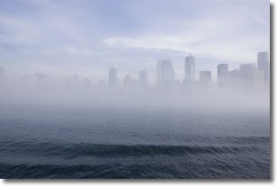
Weather Topic: What is Fog?
Home - Education - Cloud Types - Fog
 Next Topic: Fractus Clouds
Fog is technically a type of stratus cloud, which lies along the
ground and obscures visibility.
It is usually created when humidity in the air condenses into tiny water droplets.
Because of this, some places are more prone to foggy weather, such as regions
close to a body of water.
Fog is similar to mist; both are the appearance of water droplets suspended in
the air, but fog is the term applied to the condition when visibility is less than 1 km.
Next Topic: Fractus Clouds
Current conditions powered by WeatherAPI.com


