Weather Alert in Minnesota
Winter Weather Advisory issued April 2 at 6:59AM CDT until April 2 at 10:00AM CDT by NWS Twin Cities/Chanhassen MN
AREAS AFFECTED: Hennepin; Ramsey; Carver
DESCRIPTION: ...MESSY SPRING SYSTEM BRINGS FREEZING RAIN, SLEET, AND SNOW THROUGH THIS MORNING... .Western and central Minnesota will experience mainly slushy wet snow with accumulations of 2 to 4 inches, meanwhile rain is favored in southern and southeastern Minnesota. In between the snow and rain, a messy wintry mix of sleet and freezing rain will result in ice accumulations and slippery travel. There is still a moderate degree of uncertainty regarding ice accumulation amounts, due to temperatures being very close to freezing and a fluctuation of only a degree or two likely having a large impact on final amounts. The greatest impacts from icing and freezing rain will occur over western Wisconsin and east-central Minnesota, with accumulations up to a quarter inch in Minnesota and a few tenths of an inch in Wisconsin. Power outages are possible due to icing of power lines in addition to gusty winds, and slippery to impossible travel will occur where ice accumulates. Slow travel from wet slushy snow is expected in western and central Minnesota. * WHAT...Mixed precipitation. Additional snow accumulations up to one inch, sleet accumulations up to one tenth of an inch, and ice accumulations around a light glaze. * WHERE...Carver, Hennepin, and Ramsey Counties. * WHEN...Until 10 AM CDT this morning. * IMPACTS...Plan on slippery road conditions. The hazardous conditions will impact the Thursday morning commute.
INSTRUCTION: Slow down and use caution while traveling. Be prepared for slippery roads. Slow down and use caution while driving. If you are going outside, watch your first few steps taken on stairs, sidewalks, and driveways. These surfaces could be icy and slippery, increasing your risk of a fall and injury.
Want more detail? Get the Complete 7 Day and Night Detailed Forecast!
Current U.S. National Radar--Current
The Current National Weather Radar is shown below with a UTC Time (subtract 5 hours from UTC to get Eastern Time).

National Weather Forecast--Current
The Current National Weather Forecast and National Weather Map are shown below.

National Weather Forecast for Tomorrow
Tomorrow National Weather Forecast and Tomorrow National Weather Map are show below.

North America Water Vapor (Moisture)
This map shows recent moisture content over North America. Bright and colored areas show high moisture (ie, clouds); brown indicates very little moisture present; black indicates no moisture.

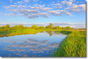
Weather Topic: What are Stratocumulus Clouds?
Home - Education - Cloud Types - Stratocumulus Clouds
 Next Topic: Stratus Clouds
Stratocumulus clouds are similar to altocumulus clouds in their
fluffy appearance, but have a slightly darker shade due to their additional mass.
A good way to distinguish the two cloud types is to hold your hand out and measure
the size of an individual cloud; if it is the size of your thumb it is generally
an altocumulus cloud, if it is the size of your hand it is generally a
stratocumulus cloud.
It is uncommon for stratocumulus clouds to produce precipitation, but if they do
it is usually a light rain or snow.
Next Topic: Stratus Clouds
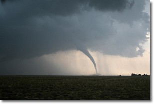
Weather Topic: What are Wall Clouds?
Home - Education - Cloud Types - Wall Clouds
 Next Topic: Altocumulus Clouds
A wall cloud forms underneath the base of a cumulonimbus cloud,
and can be a hotbed for deadly tornadoes.
Wall clouds are formed by air flowing into the cumulonimbus clouds, which can
result in the wall cloud descending from the base of the cumulonimbus cloud, or
rising fractus clouds which join to the base of the storm cloud as the wall cloud
takes shape.
Wall clouds can be very large, and in the Northern Hemisphere they generally
form at the southern edge of cumulonimbus clouds.
Next Topic: Altocumulus Clouds
Current conditions powered by WeatherAPI.com


