Weather Alert in California
Fire Weather Watch issued August 24 at 12:05AM PDT until August 25 at 11:00PM PDT by NWS Eureka CA
AREAS AFFECTED: Trinity
DESCRIPTION: ...SCATTERED DRY THUNDERSTORMS EACH AFTERNOON EARLY THIS WEEK... .Scattered dry thunderstorms expected over high terrain each afternoon early this week. Some isolated storms possible as early as Sunday afternoon with increasing storm coverage through Tuesday as far south as northern Lake County. Fuels are very dry on the heels of high heat. The National Weather Service in Eureka has issued a Fire Weather Watch, which is in effect from Monday afternoon through Monday evening. * AFFECTED AREA...Fire weather zone 283, Northern Trinity County. * THUNDERSTORMS...Mostly dry storms over high terrain in the late afternoon and evening. * OUTFLOW WINDS...Gusty and erratic outflow winds over 40 mph. * IMPACTS...any fires that develop will likely spread rapidly. Outdoor burning is not recommended.
INSTRUCTION: A Fire Weather Watch means that critical fire weather conditions are forecast to occur. Listen for later forecasts and possible Red Flag Warnings.
Want more detail? Get the Complete 7 Day and Night Detailed Forecast!
Current U.S. National Radar--Current
The Current National Weather Radar is shown below with a UTC Time (subtract 5 hours from UTC to get Eastern Time).

National Weather Forecast--Current
The Current National Weather Forecast and National Weather Map are shown below.

National Weather Forecast for Tomorrow
Tomorrow National Weather Forecast and Tomorrow National Weather Map are show below.

North America Water Vapor (Moisture)
This map shows recent moisture content over North America. Bright and colored areas show high moisture (ie, clouds); brown indicates very little moisture present; black indicates no moisture.

Weather Topic: What is Drizzle?
Home - Education - Precipitation - Drizzle
 Next Topic: Evaporation
Drizzle is precipitation in the form of water droplets which are
smaller than raindrops.
Drizzle is characterized by fine, gently falling droplets and typically does not
impact human habitation in a negative way. The exception to this is freezing drizzle,
a condition where drizzle freezes immediately upon reaching earth's surface.
Freezing drizzle is still less dangerous than freezing rain, but can
potentially result in hazardous road conditions.
Next Topic: Evaporation
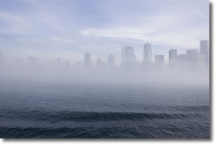
Weather Topic: What is Fog?
Home - Education - Cloud Types - Fog
 Next Topic: Fractus Clouds
Fog is technically a type of stratus cloud, which lies along the
ground and obscures visibility.
It is usually created when humidity in the air condenses into tiny water droplets.
Because of this, some places are more prone to foggy weather, such as regions
close to a body of water.
Fog is similar to mist; both are the appearance of water droplets suspended in
the air, but fog is the term applied to the condition when visibility is less than 1 km.
Next Topic: Fractus Clouds
Current conditions powered by WeatherAPI.com


