Weather Alert in New York
Coastal Flood Advisory issued February 23 at 6:14AM EST until February 23 at 6:00PM EST by NWS Upton NY
AREAS AFFECTED: Southwest Suffolk; Southern Nassau
DESCRIPTION: * WHAT...Up to a foot of inundation above ground level expected in vulnerable areas near the waterfront and shoreline. * WHERE...Southwest Suffolk and Southern Nassau Counties. * WHEN...From 11 AM this morning to 6 PM EST this evening. * COASTAL FLOOD IMPACTS...Minor coastal flooding is expected in the most vulnerable locations near the waterfront and shoreline. Expect up to 1 ft of inundation above ground level in low lying, vulnerable areas. Some roads and low lying property including parking lots, parks, lawns and homes/businesses with basements near the waterfront will experience shallow flooding. * SHORELINE IMPACTS...Breaking surf of 5 to 10 ft along the ocean front will cause widespread beach flooding and erosion during the time of high tide. Areas of dune erosion are likely, with localized washovers possible where dunes are compromised.
INSTRUCTION: If travel is required, allow extra time as some roads may be closed. Do not drive around barricades or through water of unknown depth. Take the necessary actions to protect flood-prone property.
Want more detail? Get the Complete 7 Day and Night Detailed Forecast!
Current U.S. National Radar--Current
The Current National Weather Radar is shown below with a UTC Time (subtract 5 hours from UTC to get Eastern Time).

National Weather Forecast--Current
The Current National Weather Forecast and National Weather Map are shown below.

National Weather Forecast for Tomorrow
Tomorrow National Weather Forecast and Tomorrow National Weather Map are show below.

North America Water Vapor (Moisture)
This map shows recent moisture content over North America. Bright and colored areas show high moisture (ie, clouds); brown indicates very little moisture present; black indicates no moisture.

Weather Topic: What is Freezing Rain?
Home - Education - Precipitation - Freezing Rain
 Next Topic: Graupel
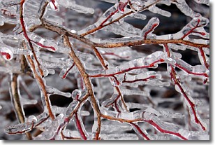
Freezing rain is a condition where precipitation which has fallen in the form of
water droplets reaches temperatures which are below freezing and freezes upon
coming into contact
with surface objects. The result of this precipitation is a glaze of ice which
can be damaging to plants and man-made structures. A severe onset of freezing
rain which results in a very thick glaze of ice is known as an ice storm.
Next Topic: Graupel
Weather Topic: What is Hail?
Home - Education - Precipitation - Hail
 Next Topic: Hole Punch Clouds
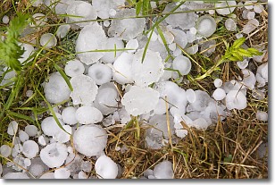
Hail is a form of precipitation which is recognized by large solid balls or
clumps of ice. Hail is created by thunderstorm clouds with strong updrafts of wind.
As the hailstones remain in the updraft, ice is deposited onto them until their
weight becomes heavy enough for them to fall to the earth's surface.
Hail storms can cause significant damage to crops, aircrafts, and man-made structures,
despite the fact that the duration is usually less than ten minutes.
Next Topic: Hole Punch Clouds
Current conditions powered by WeatherAPI.com


