Weather Alert in Indiana
Flood Warning issued March 7 at 12:58PM EST by NWS Indianapolis IN
AREAS AFFECTED: Gibson, IN; Knox, IN
DESCRIPTION: ...The Flood Warning continues for the following rivers in Indiana... Illinois... White River at Edwardsport, Spencer, Newberry, Elliston, Hazleton, and Petersburg. Wabash River at Mount Carmel. .Total rainfall amounts of 3 to over 5 inches of rain across much of central and southern Indiana is bringing widespread moderate flooding across the East Fork White and lower White basins and their tributaries. Minor flooding is expected in the lowest reach of the Wabash River at Mount Carmel starting Saturday night. Additional rainfall earlier today and next week could lengthen the amount of time area rivers remain in flood or bring additional rises next week. * WHAT...Moderate flooding is forecast. * WHERE...White River at Hazleton. * WHEN...Until further notice. * IMPACTS...At 24.8 feet, Water begins to come in the street at the corner of West 2nd Street and Brown Street in the town of Hazleton. A six inch water pump is installed at 2nd and Brown Street to keep water off the streets. * ADDITIONAL DETAILS... - There is no current observed data. - Forecast...The river is expected to rise to a crest of 24.4 feet early Wednesday morning. - Flood stage is 16.0 feet. - http://www.weather.gov/safety/flood
INSTRUCTION: Flooding is occurring or is imminent. Most flood related deaths occur in automobiles. Do not attempt to cross water covered bridges, dips, or low water crossings. Never try to cross a flowing stream, even a small one, on foot. To escape rising water find another route over higher ground. Caution is urged when walking near riverbanks. Additional information is available at www.weather.gov/ind. The next statement should be issued late tonight by around 500 AM EDT /400 AM CDT/.
Want more detail? Get the Complete 7 Day and Night Detailed Forecast!
Current U.S. National Radar--Current
The Current National Weather Radar is shown below with a UTC Time (subtract 5 hours from UTC to get Eastern Time).

National Weather Forecast--Current
The Current National Weather Forecast and National Weather Map are shown below.

National Weather Forecast for Tomorrow
Tomorrow National Weather Forecast and Tomorrow National Weather Map are show below.

North America Water Vapor (Moisture)
This map shows recent moisture content over North America. Bright and colored areas show high moisture (ie, clouds); brown indicates very little moisture present; black indicates no moisture.

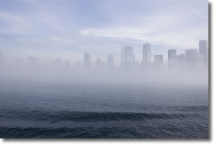
Weather Topic: What is Fog?
Home - Education - Cloud Types - Fog
 Next Topic: Fractus Clouds
Fog is technically a type of stratus cloud, which lies along the
ground and obscures visibility.
It is usually created when humidity in the air condenses into tiny water droplets.
Because of this, some places are more prone to foggy weather, such as regions
close to a body of water.
Fog is similar to mist; both are the appearance of water droplets suspended in
the air, but fog is the term applied to the condition when visibility is less than 1 km.
Next Topic: Fractus Clouds
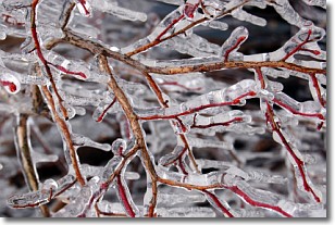
Weather Topic: What is Freezing Rain?
Home - Education - Precipitation - Freezing Rain
 Next Topic: Graupel
Freezing rain is a condition where precipitation which has fallen in the form of
water droplets reaches temperatures which are below freezing and freezes upon
coming into contact
with surface objects. The result of this precipitation is a glaze of ice which
can be damaging to plants and man-made structures. A severe onset of freezing
rain which results in a very thick glaze of ice is known as an ice storm.
Next Topic: Graupel
Current conditions powered by WeatherAPI.com


