Weather Alert in Georgia
Flood Watch issued August 23 at 7:24AM EDT until August 24 at 2:00AM EDT by NWS Charleston SC
AREAS AFFECTED: Jenkins; Screven; Candler; Bulloch; Effingham; Tattnall; Evans; Inland Bryan; Coastal Bryan; Inland Chatham; Coastal Chatham; Long; Inland Liberty; Coastal Liberty; Inland McIntosh; Coastal McIntosh; Allendale; Hampton; Inland Colleton; Dorchester; Inland Berkeley; Inland Jasper; Beaufort; Coastal Colleton; Charleston; Coastal Jasper; Tidal Berkeley
DESCRIPTION: * WHAT...Flash flooding caused by excessive rainfall continues to be possible. * WHERE...Portions of southeast Georgia, including the following areas, Bulloch, Candler, Coastal Bryan, Coastal Chatham, Coastal Liberty, Coastal McIntosh, Effingham, Evans, Inland Bryan, Inland Chatham, Inland Liberty, Inland McIntosh, Jenkins, Long, Screven and Tattnall and southeast South Carolina, including the following areas, Allendale, Beaufort, Charleston, Coastal Colleton, Coastal Jasper, Dorchester, Hampton, Inland Berkeley, Inland Colleton, Inland Jasper and Tidal Berkeley. * WHEN...Through late tonight. * IMPACTS...Excessive runoff may result in flooding of rivers, creeks, streams, and other low-lying and flood-prone locations. Creeks and streams may rise out of their banks. Flooding may occur in poor drainage and urban areas. Storm drains and ditches may become clogged with debris. Extensive street flooding and flooding of creeks and rivers are possible. * ADDITIONAL DETAILS... - Showers and thunderstorms produced numerous areas of 3 to 5 inches, with localized areas receiving in excess of 7 inches, of rainfall on Friday across southeast Georgia and the South Carolina. An additional 1.5 to 2.5 inches of rainfall can be expected across the region through this evening. The heaviest rainfall should occur generally along and east of the Interstate 95 corridor, some areas possibly receiving in excess of 4 inches. The additional rainfall falling on nearly saturated soil will likely lead to rapid runoff, possibly producing flash flooding. Several streams and creeks have elevated water levels following the heavy rainfall that occurred on Friday. Based on the forecast rainfall, Church Creek near West Ashley, French Quarter Creek near Huger, and Ireland Creek at Walterboro could see water levels crest above flood stage. In addition, flash flooding may develop within coastal cities with any heavy downpours that coincide with high tide this morning or this evening. - http://www.weather.gov/safety/flood
INSTRUCTION: Be prepared to protect life and property, especially in areas prone to flooding. If flooding develops, move to higher ground immediately. If driving, be prepared for flooded roadways and possible road closures.
Want more detail? Get the Complete 7 Day and Night Detailed Forecast!
Current U.S. National Radar--Current
The Current National Weather Radar is shown below with a UTC Time (subtract 5 hours from UTC to get Eastern Time).

National Weather Forecast--Current
The Current National Weather Forecast and National Weather Map are shown below.

National Weather Forecast for Tomorrow
Tomorrow National Weather Forecast and Tomorrow National Weather Map are show below.

North America Water Vapor (Moisture)
This map shows recent moisture content over North America. Bright and colored areas show high moisture (ie, clouds); brown indicates very little moisture present; black indicates no moisture.

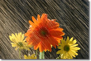
Weather Topic: What is Precipitation?
Home - Education - Precipitation - Precipitation
 Next Topic: Rain
Precipitation can refer to many different forms of water that
may fall from clouds. Precipitation occurs after a cloud has become saturated to
the point where its water particles are more dense than the air below the cloud.
In most cases, precipitation will reach the ground, but it is not uncommon for
precipitation to evaporate before it reaches the earth's surface.
When precipitation evaporates before it contacts the ground it is called Virga.
Graupel, hail, sleet, rain, drizzle, and snow are forms of precipitation, but fog
and mist are not considered precipitation because the water vapor which
constitutes them isn't dense enough to fall to the ground.
Next Topic: Rain
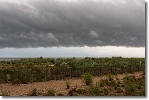
Weather Topic: What are Shelf Clouds?
Home - Education - Cloud Types - Shelf Clouds
 Next Topic: Sleet
A shelf cloud is similar to a wall cloud, but forms at the front
of a storm cloud, instead of at the rear, where wall clouds form.
A shelf cloud is caused by a series of events set into motion by the advancing
storm; first, cool air settles along the ground where precipitation has just fallen.
As the cool air is brought in, the warmer air is displaced, and rises above it,
because it is less dense. When the warmer air reaches the bottom of the storm cloud,
it begins to cool again, and the resulting condensation is a visible shelf cloud.
Next Topic: Sleet
Current conditions powered by WeatherAPI.com


