Weather Alert in Alaska
Winter Weather Advisory issued February 22 at 10:19AM AKST until February 24 at 3:00AM AKST by NWS Anchorage AK
AREAS AFFECTED: Northern Alaska Peninsula; Bristol Bay Borough (Naknek and King Salmon); Lake Iliamna / Nila Vena / Nanvarpak
DESCRIPTION: * WHAT...Mixed precipitation expected. Total snow accumulations up to 1 inch and ice accumulations around one tenth of an inch. * WHERE...Bristol Bay Borough (Naknek and King Salmon), Lake Iliamna / Nila Vena / Nanvarpak, and Northern Alaska Peninsula. * WHEN...From 11 AM Monday to 3 AM AKST Tuesday. * IMPACTS...Travel could be very difficult. * ADDITIONAL DETAILS...Warm onshore flow will raise temperatures into the low to mid 30's by Monday. Freezing rain is expected to begin just before noon Monday and persist through Tuesday morning. Freezing rain mixes with snow by Tuesday morning as winds flip to northerly and a cold airmass moves back in.
INSTRUCTION: Slow down and use caution while traveling.
Want more detail? Get the Complete 7 Day and Night Detailed Forecast!
Current U.S. National Radar--Current
The Current National Weather Radar is shown below with a UTC Time (subtract 5 hours from UTC to get Eastern Time).

National Weather Forecast--Current
The Current National Weather Forecast and National Weather Map are shown below.

National Weather Forecast for Tomorrow
Tomorrow National Weather Forecast and Tomorrow National Weather Map are show below.

North America Water Vapor (Moisture)
This map shows recent moisture content over North America. Bright and colored areas show high moisture (ie, clouds); brown indicates very little moisture present; black indicates no moisture.

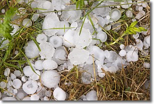
Weather Topic: What is Hail?
Home - Education - Precipitation - Hail
 Next Topic: Hole Punch Clouds
Hail is a form of precipitation which is recognized by large solid balls or
clumps of ice. Hail is created by thunderstorm clouds with strong updrafts of wind.
As the hailstones remain in the updraft, ice is deposited onto them until their
weight becomes heavy enough for them to fall to the earth's surface.
Hail storms can cause significant damage to crops, aircrafts, and man-made structures,
despite the fact that the duration is usually less than ten minutes.
Next Topic: Hole Punch Clouds
Weather Topic: What are Mammatus Clouds?
Home - Education - Cloud Types - Mammatus Clouds
 Next Topic: Nimbostratus Clouds
A mammatus cloud is a cloud with a unique feature which resembles
a web of pouches hanging along the base of the cloud.
In the United States, mammatus clouds tend to form in the warmer months, commonly
in the Midwest and eastern regions.
While they usually form at the bottom of a cumulonimbis cloud, they can also form
under altostratus, altocumulus, stratocumulus, and cirrus clouds. Mammatus clouds
warn that severe weather is close.
Next Topic: Nimbostratus Clouds
Current conditions powered by WeatherAPI.com


