Weather Alert in Minnesota
Winter Storm Watch issued March 31 at 2:24PM CDT until April 3 at 1:00AM CDT by NWS Duluth MN
AREAS AFFECTED: Northern Cook/Northern Lake; Central St. Louis; Southern Lake/North Shore; Southern Cook/North Shore; Carlton/South St. Louis; Pine; Douglas; Bayfield; Ashland; Iron
DESCRIPTION: * WHAT...Heavy mixed precipitation possible. Total snow and sleet accumulations between 4 and 9 inches except between 7 and 10 inches for the higher terrain of the North Shore and ice accumulations around one tenth of an inch possible. Winds could gust as high as 35 mph. * WHERE...In Minnesota, Pine, Carlton, South and Central St. Louis, Cook and Lake Counties. In Wisconsin, Ashland, Bayfield, Douglas, and Iron Counties. This includes the Tribal Lands of the Red Cliff Band, the Bois Forte Band, Lake Vermilion area, the Fond du Lac Band, the Grand Portage Reservation, the Bad River Reservation, the northwestern area of the Lac du Flambeau Band and the Mille Lacs Band, Hinckley and, Lena Lake areas. Other locations including the Apostle Islands National Lakeshore and Madeline Island. This also includes the Boundary Waters eastern and central area. * WHEN...From Wednesday evening through late Thursday night. * IMPACTS...Travel could be very difficult. The hazardous conditions could impact the Thursday morning and evening commutes.
INSTRUCTION: Monitor the latest forecasts for updates on this situation.
Want more detail? Get the Complete 7 Day and Night Detailed Forecast!
Current U.S. National Radar--Current
The Current National Weather Radar is shown below with a UTC Time (subtract 5 hours from UTC to get Eastern Time).

National Weather Forecast--Current
The Current National Weather Forecast and National Weather Map are shown below.

National Weather Forecast for Tomorrow
Tomorrow National Weather Forecast and Tomorrow National Weather Map are show below.

North America Water Vapor (Moisture)
This map shows recent moisture content over North America. Bright and colored areas show high moisture (ie, clouds); brown indicates very little moisture present; black indicates no moisture.

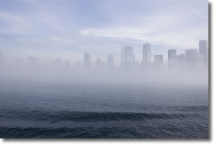
Weather Topic: What is Fog?
Home - Education - Cloud Types - Fog
 Next Topic: Fractus Clouds
Fog is technically a type of stratus cloud, which lies along the
ground and obscures visibility.
It is usually created when humidity in the air condenses into tiny water droplets.
Because of this, some places are more prone to foggy weather, such as regions
close to a body of water.
Fog is similar to mist; both are the appearance of water droplets suspended in
the air, but fog is the term applied to the condition when visibility is less than 1 km.
Next Topic: Fractus Clouds
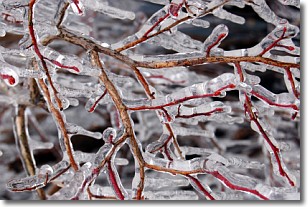
Weather Topic: What is Freezing Rain?
Home - Education - Precipitation - Freezing Rain
 Next Topic: Graupel
Freezing rain is a condition where precipitation which has fallen in the form of
water droplets reaches temperatures which are below freezing and freezes upon
coming into contact
with surface objects. The result of this precipitation is a glaze of ice which
can be damaging to plants and man-made structures. A severe onset of freezing
rain which results in a very thick glaze of ice is known as an ice storm.
Next Topic: Graupel
Current conditions powered by WeatherAPI.com


