Weather Alert in Ohio
Flood Warning issued April 25 at 9:26PM EDT until April 26 at 2:00AM EDT by NWS Cleveland OH
AREAS AFFECTED: Cuyahoga, OH
DESCRIPTION: * WHAT...Flooding caused by excessive rainfall is expected. * WHERE...A portion of northeast Ohio, including the following county, Cuyahoga. * WHEN...Until 200 AM EDT. * IMPACTS...Flooding of rivers, creeks, streams, and other low-lying and flood-prone locations is imminent or occurring. * ADDITIONAL DETAILS... - At 926 PM EDT, Doppler radar indicated heavy rain due to thunderstorms. Flooding is ongoing or expected to begin shortly in the warned area. Between 2 and 3 inches of rain have fallen. - Flooding impacts will continue, but no additional rainfall is expected. - Some locations that will experience flooding include... Cleveland, Solon, Warrensville Heights, Macedonia, Highland Hills, Garfield Heights, Maple Heights, Brecksville, Bedford, Beachwood, Bedford Heights, Independence, Pepper Pike, Chagrin Falls, Northfield, Orange, Moreland Hills, Walton Hills, Valley View and North Randall. - Please visit www.weather.gov/safety/flood for flood safety and preparedness information.
INSTRUCTION: Turn around, don't drown when encountering flooded roads. Most flood deaths occur in vehicles.
Want more detail? Get the Complete 7 Day and Night Detailed Forecast!
Current U.S. National Radar--Current
The Current National Weather Radar is shown below with a UTC Time (subtract 5 hours from UTC to get Eastern Time).

National Weather Forecast--Current
The Current National Weather Forecast and National Weather Map are shown below.

National Weather Forecast for Tomorrow
Tomorrow National Weather Forecast and Tomorrow National Weather Map are show below.

North America Water Vapor (Moisture)
This map shows recent moisture content over North America. Bright and colored areas show high moisture (ie, clouds); brown indicates very little moisture present; black indicates no moisture.

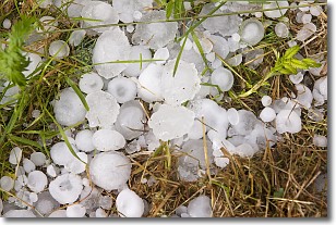
Weather Topic: What is Hail?
Home - Education - Precipitation - Hail
 Next Topic: Hole Punch Clouds
Hail is a form of precipitation which is recognized by large solid balls or
clumps of ice. Hail is created by thunderstorm clouds with strong updrafts of wind.
As the hailstones remain in the updraft, ice is deposited onto them until their
weight becomes heavy enough for them to fall to the earth's surface.
Hail storms can cause significant damage to crops, aircrafts, and man-made structures,
despite the fact that the duration is usually less than ten minutes.
Next Topic: Hole Punch Clouds
Weather Topic: What are Mammatus Clouds?
Home - Education - Cloud Types - Mammatus Clouds
 Next Topic: Nimbostratus Clouds
A mammatus cloud is a cloud with a unique feature which resembles
a web of pouches hanging along the base of the cloud.
In the United States, mammatus clouds tend to form in the warmer months, commonly
in the Midwest and eastern regions.
While they usually form at the bottom of a cumulonimbis cloud, they can also form
under altostratus, altocumulus, stratocumulus, and cirrus clouds. Mammatus clouds
warn that severe weather is close.
Next Topic: Nimbostratus Clouds
Current conditions powered by WeatherAPI.com


