Weather Alert in Ohio
Flood Warning issued April 25 at 9:26PM EDT until April 26 at 2:00AM EDT by NWS Cleveland OH
AREAS AFFECTED: Cuyahoga, OH
DESCRIPTION: * WHAT...Flooding caused by excessive rainfall is expected. * WHERE...A portion of northeast Ohio, including the following county, Cuyahoga. * WHEN...Until 200 AM EDT. * IMPACTS...Flooding of rivers, creeks, streams, and other low-lying and flood-prone locations is imminent or occurring. * ADDITIONAL DETAILS... - At 926 PM EDT, Doppler radar indicated heavy rain due to thunderstorms. Flooding is ongoing or expected to begin shortly in the warned area. Between 2 and 3 inches of rain have fallen. - Flooding impacts will continue, but no additional rainfall is expected. - Some locations that will experience flooding include... Cleveland, Solon, Warrensville Heights, Macedonia, Highland Hills, Garfield Heights, Maple Heights, Brecksville, Bedford, Beachwood, Bedford Heights, Independence, Pepper Pike, Chagrin Falls, Northfield, Orange, Moreland Hills, Walton Hills, Valley View and North Randall. - Please visit www.weather.gov/safety/flood for flood safety and preparedness information.
INSTRUCTION: Turn around, don't drown when encountering flooded roads. Most flood deaths occur in vehicles.
Want more detail? Get the Complete 7 Day and Night Detailed Forecast!
Current U.S. National Radar--Current
The Current National Weather Radar is shown below with a UTC Time (subtract 5 hours from UTC to get Eastern Time).

National Weather Forecast--Current
The Current National Weather Forecast and National Weather Map are shown below.

National Weather Forecast for Tomorrow
Tomorrow National Weather Forecast and Tomorrow National Weather Map are show below.

North America Water Vapor (Moisture)
This map shows recent moisture content over North America. Bright and colored areas show high moisture (ie, clouds); brown indicates very little moisture present; black indicates no moisture.

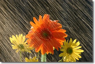
Weather Topic: What is Precipitation?
Home - Education - Precipitation - Precipitation
 Next Topic: Rain
Precipitation can refer to many different forms of water that
may fall from clouds. Precipitation occurs after a cloud has become saturated to
the point where its water particles are more dense than the air below the cloud.
In most cases, precipitation will reach the ground, but it is not uncommon for
precipitation to evaporate before it reaches the earth's surface.
When precipitation evaporates before it contacts the ground it is called Virga.
Graupel, hail, sleet, rain, drizzle, and snow are forms of precipitation, but fog
and mist are not considered precipitation because the water vapor which
constitutes them isn't dense enough to fall to the ground.
Next Topic: Rain
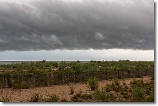
Weather Topic: What are Shelf Clouds?
Home - Education - Cloud Types - Shelf Clouds
 Next Topic: Sleet
A shelf cloud is similar to a wall cloud, but forms at the front
of a storm cloud, instead of at the rear, where wall clouds form.
A shelf cloud is caused by a series of events set into motion by the advancing
storm; first, cool air settles along the ground where precipitation has just fallen.
As the cool air is brought in, the warmer air is displaced, and rises above it,
because it is less dense. When the warmer air reaches the bottom of the storm cloud,
it begins to cool again, and the resulting condensation is a visible shelf cloud.
Next Topic: Sleet
Current conditions powered by WeatherAPI.com


