Weather Alert in California
Flood Watch issued February 23 at 3:04PM PST until February 24 at 10:00PM PST by NWS Eureka CA
AREAS AFFECTED: Southeastern Mendocino Interior
DESCRIPTION: ...The National Weather Service in Eureka has issued a Flood Watch for the following rivers in California... Russian River near Hopland affecting Southeastern Mendocino Interior zone. For the Russian River...including Hopland...flooding is possible. * WHAT...Flooding is possible. * WHERE...Russian River near Hopland. * WHEN...From Tuesday afternoon to Tuesday evening. * IMPACTS...At 15.0 feet, Flooding of Highway 175 is expected at the approaches to the Russian River bridge. Expect flooding of cropland on the right bank of river. * ADDITIONAL DETAILS... - At 2:45 PM PST Monday the stage was 3.5 feet. - Forecast...Flood stage may be reached tomorrow afternoon. - Flood stage is 15.0 feet. - http://www.weather.gov/safety/flood
INSTRUCTION: If you are in the watch area, remain alert to possible flooding. Residents and those with interests near the river should monitor rising water levels and be prepared for possible Flood Warnings. Please report observed flooding to local emergency services or law enforcement and request they pass this information to the National Weather Service when you can do so safely. Stay tuned to further developments by listening to your local radio, television, or NOAA Weather Radio for further information. Additional information is available at weather.gov/eka. The next statement will be issued this evening at 1115 PM PST.
Want more detail? Get the Complete 7 Day and Night Detailed Forecast!
Current U.S. National Radar--Current
The Current National Weather Radar is shown below with a UTC Time (subtract 5 hours from UTC to get Eastern Time).

National Weather Forecast--Current
The Current National Weather Forecast and National Weather Map are shown below.

National Weather Forecast for Tomorrow
Tomorrow National Weather Forecast and Tomorrow National Weather Map are show below.

North America Water Vapor (Moisture)
This map shows recent moisture content over North America. Bright and colored areas show high moisture (ie, clouds); brown indicates very little moisture present; black indicates no moisture.

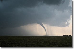
Weather Topic: What are Wall Clouds?
Home - Education - Cloud Types - Wall Clouds
 Next Topic: Altocumulus Clouds
A wall cloud forms underneath the base of a cumulonimbus cloud,
and can be a hotbed for deadly tornadoes.
Wall clouds are formed by air flowing into the cumulonimbus clouds, which can
result in the wall cloud descending from the base of the cumulonimbus cloud, or
rising fractus clouds which join to the base of the storm cloud as the wall cloud
takes shape.
Wall clouds can be very large, and in the Northern Hemisphere they generally
form at the southern edge of cumulonimbus clouds.
Next Topic: Altocumulus Clouds
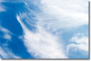
Weather Topic: What are Altostratus Clouds?
Home - Education - Cloud Types - Altostratus Clouds
 Next Topic: Cirrocumulus Clouds
Altostratus clouds form at mid to high-level altitudes
(between 2 and 7 km) and are created by a warm, stable air mass which causes
water vapor
to condense as it rise through the atmosphere. Usually altostratus clouds are
featureless sheets characterized by a uniform color.
In some cases, wind punching through the cloud formation may give it a waved
appearance, called altostratus undulatus. Altostratus clouds
are commonly seen with other cloud formations accompanying them.
Next Topic: Cirrocumulus Clouds
Current conditions powered by WeatherAPI.com


