Weather Alert in Tennessee
Special Weather Statement issued September 5 at 8:12PM CDT by NWS Nashville TN
AREAS AFFECTED: Robertson; Sumner; Davidson; Wilson
DESCRIPTION: At 812 PM CDT, Doppler radar was tracking a strong thunderstorm over Nashville, moving east at 30 mph. HAZARD...Wind gusts up to 40 mph and pea size hail. SOURCE...Radar indicated. IMPACT...Gusty winds could knock down tree limbs and blow around unsecured objects. Minor hail damage to vegetation is possible. Locations impacted include... Gallatin, Lebanon, Nashville, Madison, Hendersonville, Mount Juliet, Goodlettsville, Millersville, Greenbrier, Forest Hills, Oak Hill, Belle Meade, Lakewood, Ridgetop, Hermitage, Rural Hill, Belinda City, Old Hickory, Joelton, and Berry Hill. This includes the following highways... Interstate 40 between mile markers 205 and 230. Interstate 65 between mile markers 78 and 103. Interstate 24 between mile markers 36 and 56. Interstate 840 near mile marker 69.
INSTRUCTION: If outdoors, consider seeking shelter inside a building. A Severe Thunderstorm Watch remains in effect until midnight CDT for Middle Tennessee.
Want more detail? Get the Complete 7 Day and Night Detailed Forecast!
Current U.S. National Radar--Current
The Current National Weather Radar is shown below with a UTC Time (subtract 5 hours from UTC to get Eastern Time).

National Weather Forecast--Current
The Current National Weather Forecast and National Weather Map are shown below.

National Weather Forecast for Tomorrow
Tomorrow National Weather Forecast and Tomorrow National Weather Map are show below.

North America Water Vapor (Moisture)
This map shows recent moisture content over North America. Bright and colored areas show high moisture (ie, clouds); brown indicates very little moisture present; black indicates no moisture.

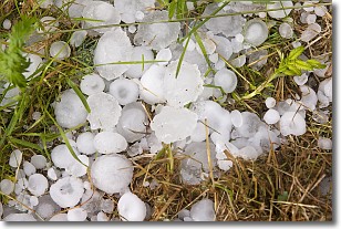
Weather Topic: What is Hail?
Home - Education - Precipitation - Hail
 Next Topic: Hole Punch Clouds
Hail is a form of precipitation which is recognized by large solid balls or
clumps of ice. Hail is created by thunderstorm clouds with strong updrafts of wind.
As the hailstones remain in the updraft, ice is deposited onto them until their
weight becomes heavy enough for them to fall to the earth's surface.
Hail storms can cause significant damage to crops, aircrafts, and man-made structures,
despite the fact that the duration is usually less than ten minutes.
Next Topic: Hole Punch Clouds
Weather Topic: What are Mammatus Clouds?
Home - Education - Cloud Types - Mammatus Clouds
 Next Topic: Nimbostratus Clouds
A mammatus cloud is a cloud with a unique feature which resembles
a web of pouches hanging along the base of the cloud.
In the United States, mammatus clouds tend to form in the warmer months, commonly
in the Midwest and eastern regions.
While they usually form at the bottom of a cumulonimbis cloud, they can also form
under altostratus, altocumulus, stratocumulus, and cirrus clouds. Mammatus clouds
warn that severe weather is close.
Next Topic: Nimbostratus Clouds
Current conditions powered by WeatherAPI.com


