Weather Alert in Wisconsin
Flood Warning issued August 14 at 9:07PM CDT until August 16 at 1:00PM CDT by NWS Milwaukee/Sullivan WI
AREAS AFFECTED: Waukesha, WI
DESCRIPTION: ...The Flood Warning is extended for the following river in Wisconsin... Fox River Lower At Waukesha affecting Waukesha County. * WHAT...Minor flooding is occurring and minor flooding is forecast. This approaches the flood of record. * WHERE...Fox River Lower at Waukesha. * WHEN...Until early Saturday afternoon. * IMPACTS...At 7.0 feet, Water is over the banks of Frame Park and floodwaters are at least 2 feet deep on land near the shoreline. About one half mile south of downtown Waukesha, water is 2 to 3 feet deep and covering much of the back yards of 6 or 7 homes in the Bethesda Court area of Waukesha. * ADDITIONAL DETAILS... - At 8:00 PM CDT Thursday the stage was 7.1 feet. - Bankfull stage is 5.0 feet. - Recent Activity...The maximum river stage in the 24 hours ending at 8:00 PM CDT Thursday was 7.7 feet. - Forecast...The river is expected to fall below flood stage Saturday morning and continue falling to 4.0 feet Thursday, August 21. - Flood stage is 6.0 feet. - Flood History...This crest compares to a previous crest of 7.0 feet on 07/12/2017. - http://www.weather.gov/safety/flood
INSTRUCTION: Motorists should not attempt to drive around barricades or drive cars through flooded areas. Caution is urged when walking near riverbanks. Additional information is available at www.weather.gov. The next statement will be issued Friday morning at 915 AM CDT.
Want more detail? Get the Complete 7 Day and Night Detailed Forecast!
Current U.S. National Radar--Current
The Current National Weather Radar is shown below with a UTC Time (subtract 5 hours from UTC to get Eastern Time).

National Weather Forecast--Current
The Current National Weather Forecast and National Weather Map are shown below.

National Weather Forecast for Tomorrow
Tomorrow National Weather Forecast and Tomorrow National Weather Map are show below.

North America Water Vapor (Moisture)
This map shows recent moisture content over North America. Bright and colored areas show high moisture (ie, clouds); brown indicates very little moisture present; black indicates no moisture.

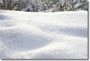
Weather Topic: What is Snow?
Home - Education - Precipitation - Snow
 Next Topic: Stratocumulus Clouds
Snow is precipitation taking the form of ice crystals. Each ice crystal, or snowflake,
has unique characteristics, but all of them grow in a hexagonal structure.
Snowfall can last for sustained periods of time and result in significant buildup
of snow on the ground.
On the earth's surface, snow starts out light and powdery, but as it begins to melt
it tends to become more granular, producing small bits of ice which have the consistency of
sand. After several cycles of melting and freezing, snow can become very dense
and ice-like, commonly known as snow pack.
Next Topic: Stratocumulus Clouds
Weather Topic: What are Stratus Clouds?
Home - Education - Cloud Types - Stratus Clouds
 Next Topic: Wall Clouds
Stratus clouds are similar to altostratus clouds, but form at a
lower altitude and are identified by their fog-like appearance, lacking the
distinguishing features of most clouds.
Stratus clouds are wider than most clouds, and their base has a smooth, uniform
look which is lighter in color than a nimbostratus cloud.
The presence of a stratus cloud indicates the possibility of minor precipitation,
such as drizzle, but heavier precipitation does not typically arrive in the form
of a stratus cloud.
Next Topic: Wall Clouds
Current conditions powered by WeatherAPI.com


