Weather Alert in Texas
Flood Advisory issued June 11 at 10:16PM CDT until June 12 at 2:30AM CDT by NWS Austin/San Antonio TX
AREAS AFFECTED: Bandera, TX; Bexar, TX; Blanco, TX; Burnet, TX; Comal, TX; Gillespie, TX; Hays, TX; Kendall, TX; Llano, TX
DESCRIPTION: * WHAT...Small stream flooding caused by excessive rainfall is expected. * WHERE...A portion of south central Texas, including the following counties, Bandera, Bexar, Blanco, Burnet, Comal, Gillespie, Hays, Kendall and Llano. * WHEN...Until 230 AM CDT. * IMPACTS...Minor flooding in low-lying and poor drainage areas. River or stream flows are elevated. * ADDITIONAL DETAILS... - At 1016 PM CDT, Doppler radar indicated heavy rain due to thunderstorms. This will cause small stream flooding. Between 1 and 3 inches of rain have fallen. - Additional rainfall amounts up to 2 inches are expected over the area. This additional rain will result in minor flooding. - Some locations that will experience flooding include... San Antonio, Boerne, Burnet, Marble Falls, Kingsland, Blanco, Round Mountain, Buchanan Dam, Canyon Lake, Gainesville, Fair Oaks Ranch, Granite Shoals, Bulverde, Horseshoe Bay, Cross Mountain, Johnson City, Meadowlakes, Buchanan Lake Village, Highland Haven and Sandy. - http://www.weather.gov/safety/flood
INSTRUCTION: Turn around, don't drown when encountering flooded roads. Most flood deaths occur in vehicles. Be especially cautious at night when it is harder to recognize the dangers of flooding. In hilly terrain there are hundreds of low water crossings which are potentially dangerous in heavy rain. Do not attempt to cross flooded roads. Find an alternate route.
Want more detail? Get the Complete 7 Day and Night Detailed Forecast!
Current U.S. National Radar--Current
The Current National Weather Radar is shown below with a UTC Time (subtract 5 hours from UTC to get Eastern Time).

National Weather Forecast--Current
The Current National Weather Forecast and National Weather Map are shown below.

National Weather Forecast for Tomorrow
Tomorrow National Weather Forecast and Tomorrow National Weather Map are show below.

North America Water Vapor (Moisture)
This map shows recent moisture content over North America. Bright and colored areas show high moisture (ie, clouds); brown indicates very little moisture present; black indicates no moisture.

Weather Topic: What is Freezing Rain?
Home - Education - Precipitation - Freezing Rain
 Next Topic: Graupel
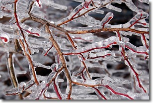
Freezing rain is a condition where precipitation which has fallen in the form of
water droplets reaches temperatures which are below freezing and freezes upon
coming into contact
with surface objects. The result of this precipitation is a glaze of ice which
can be damaging to plants and man-made structures. A severe onset of freezing
rain which results in a very thick glaze of ice is known as an ice storm.
Next Topic: Graupel
Weather Topic: What is Hail?
Home - Education - Precipitation - Hail
 Next Topic: Hole Punch Clouds
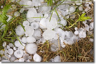
Hail is a form of precipitation which is recognized by large solid balls or
clumps of ice. Hail is created by thunderstorm clouds with strong updrafts of wind.
As the hailstones remain in the updraft, ice is deposited onto them until their
weight becomes heavy enough for them to fall to the earth's surface.
Hail storms can cause significant damage to crops, aircrafts, and man-made structures,
despite the fact that the duration is usually less than ten minutes.
Next Topic: Hole Punch Clouds
Current conditions powered by WeatherAPI.com


