Weather Alert in Indiana
Flood Warning issued March 4 at 12:17PM EST until March 11 at 3:38AM EDT by NWS Indianapolis IN
AREAS AFFECTED: Daviess, IN; Greene, IN; Knox, IN
DESCRIPTION: ...The National Weather Service in Indianapolis IN has issued a Flood Warning for the following rivers in Indiana... White River below Eagle Valley Power Plant. White River near Centerton. White River at Edwardsport. White River at Petersburg. ...Forecast flooding changed from Minor to Moderate severity and increased in duration for the following rivers in Indiana... White River at Elliston. White River at Newberry. .Rainfall amounts between two and four inches over parts of central and southern Indiana have led to rises and some flooding on area rivers. Additional rainfall of one to three inches this evening into Thursday morning, with locally higher amounts possible, will bring widespread minor river flooding with pockets of moderate flooding to much of the East Fork White and lower White River basins. * WHAT...Moderate flooding is forecast. * WHERE...White River at Newberry. * WHEN...From late tonight to Wednesday, March 11. * IMPACTS...At 20.0 feet, County Road 550 W in Green County is impassable. * ADDITIONAL DETAILS... - At 11:30 AM EST Wednesday the stage was 8.3 feet. - Forecast...The river is expected to rise above flood stage just after midnight tonight to a crest of 20.0 feet Saturday morning. It will then fall below flood stage Tuesday afternoon. - Flood stage is 13.0 feet. - http://www.weather.gov/safety/flood
INSTRUCTION: Motorists should not attempt to drive around barricades or drive cars through flooded areas. Additional information is available at www.weather.gov/ind. The next statement should be issued this evening by around 1130 PM EST /1030 PM CST/.
Want more detail? Get the Complete 7 Day and Night Detailed Forecast!
Current U.S. National Radar--Current
The Current National Weather Radar is shown below with a UTC Time (subtract 5 hours from UTC to get Eastern Time).

National Weather Forecast--Current
The Current National Weather Forecast and National Weather Map are shown below.

National Weather Forecast for Tomorrow
Tomorrow National Weather Forecast and Tomorrow National Weather Map are show below.

North America Water Vapor (Moisture)
This map shows recent moisture content over North America. Bright and colored areas show high moisture (ie, clouds); brown indicates very little moisture present; black indicates no moisture.

Weather Topic: What is Drizzle?
Home - Education - Precipitation - Drizzle
 Next Topic: Evaporation
Drizzle is precipitation in the form of water droplets which are
smaller than raindrops.
Drizzle is characterized by fine, gently falling droplets and typically does not
impact human habitation in a negative way. The exception to this is freezing drizzle,
a condition where drizzle freezes immediately upon reaching earth's surface.
Freezing drizzle is still less dangerous than freezing rain, but can
potentially result in hazardous road conditions.
Next Topic: Evaporation
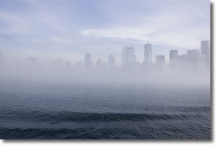
Weather Topic: What is Fog?
Home - Education - Cloud Types - Fog
 Next Topic: Fractus Clouds
Fog is technically a type of stratus cloud, which lies along the
ground and obscures visibility.
It is usually created when humidity in the air condenses into tiny water droplets.
Because of this, some places are more prone to foggy weather, such as regions
close to a body of water.
Fog is similar to mist; both are the appearance of water droplets suspended in
the air, but fog is the term applied to the condition when visibility is less than 1 km.
Next Topic: Fractus Clouds
Current conditions powered by WeatherAPI.com


