Weather Alert in Wisconsin
Special Weather Statement issued March 31 at 10:57AM CDT by NWS Green Bay WI
AREAS AFFECTED: Outagamie; Brown; Kewaunee; Winnebago; Calumet; Manitowoc
DESCRIPTION: At 1056 AM CDT, Doppler radar was tracking strong thunderstorms along a line extending from 6 miles west of Bellevue to 10 miles west of Menasha. Movement was east at 45 mph. HAZARD...Wind gusts up to 40 mph and nickel size hail. SOURCE...Radar indicated. IMPACT...Gusty winds could knock down tree limbs and blow around unsecured objects. Minor hail damage to vegetation is possible. Strong thunderstorms will be near... Green Bay, Appleton, Menasha, Kaukauna, Little Chute, Kimberly, Bellevue, Darboy, and Northern Lake Winnebago around 1100 AM CDT. Denmark and High Cliff State Park around 1115 AM CDT. Brillion around 1120 AM CDT. Kewaunee around 1130 AM CDT. Two Creeks around 1140 AM CDT. Manitowoc around 1150 AM CDT. Other locations impacted by these storms include Curran, Wayside, Freedom, Newtonberg, St John, Shirley, Potter, Cooperstown, Uw Fox Valley, and Murphy Corner.
INSTRUCTION: If outdoors, consider seeking shelter inside a building. Frequent cloud to ground lightning is occurring with these storms. Lightning can strike 10 miles away from a thunderstorm. Seek a safe shelter inside a building or vehicle.
Want more detail? Get the Complete 7 Day and Night Detailed Forecast!
Current U.S. National Radar--Current
The Current National Weather Radar is shown below with a UTC Time (subtract 5 hours from UTC to get Eastern Time).

National Weather Forecast--Current
The Current National Weather Forecast and National Weather Map are shown below.

National Weather Forecast for Tomorrow
Tomorrow National Weather Forecast and Tomorrow National Weather Map are show below.

North America Water Vapor (Moisture)
This map shows recent moisture content over North America. Bright and colored areas show high moisture (ie, clouds); brown indicates very little moisture present; black indicates no moisture.

Weather Topic: What is Sleet?
Home - Education - Precipitation - Sleet
 Next Topic: Snow
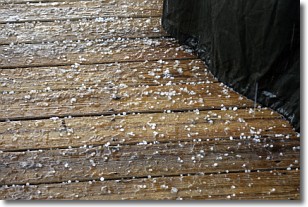
Sleet is a form of precipitation in which small ice pellets are the primary
components. These ice pellets are smaller and more translucent than hailstones,
and harder than graupel. Sleet is caused by specific atmospheric conditions and
therefore typically doesn't last for extended periods of time.
The condition which leads to sleet formation requires a warmer body of air to be
wedged in between two sub-freezing bodies of air. When snow falls through a warmer
layer of air it melts, and as it falls through the next sub-freezing body of air
it freezes again, forming ice pellets known as sleet. In some cases, water
droplets don't have time to freeze before reaching the surface and the result is
freezing rain.
Next Topic: Snow
Weather Topic: What are Stratocumulus Clouds?
Home - Education - Cloud Types - Stratocumulus Clouds
 Next Topic: Stratus Clouds
Stratocumulus clouds are similar to altocumulus clouds in their
fluffy appearance, but have a slightly darker shade due to their additional mass.
A good way to distinguish the two cloud types is to hold your hand out and measure
the size of an individual cloud; if it is the size of your thumb it is generally
an altocumulus cloud, if it is the size of your hand it is generally a
stratocumulus cloud.
It is uncommon for stratocumulus clouds to produce precipitation, but if they do
it is usually a light rain or snow.
Next Topic: Stratus Clouds
Current conditions powered by WeatherAPI.com


