Weather Alert in California
Flood Advisory issued February 24 at 5:39AM PST until February 24 at 10:00AM PST by NWS Eureka CA
AREAS AFFECTED: Humboldt, CA; Mendocino, CA; Trinity, CA
DESCRIPTION: * WHAT...Urban area and small stream flooding caused by excessive rainfall continues. * WHERE...Southeastern Humboldt County in northwestern California... Northeastern Mendocino County in northwestern California... Southwestern Trinity County in northwestern California... * WHEN...Until 1000 AM PST. * IMPACTS...Minor flooding in low-lying and poor drainage areas. Ponding of water in urban or other areas is occurring or is imminent. There will be an increased risk of rock and land slides along roadways. * ADDITIONAL DETAILS... - At 539 AM PST, Doppler radar and automated rain gauges indicated heavy rain. This is causing urban and small stream flooding. Overflowing poor drainage areas have already caused minor flooding in the advisory area. Between 1 and 2 inches of rain have fallen. - Additional rainfall amounts of 1 to 3 inches are expected over the area. This additional rain will result in minor flooding. - Some locations that will experience flooding include... Willits, Garberville, Richardson Grove State Park, Covelo, Laytonville, Hayfork, Grizzly Creek Redwoods State Park, Alderpoint, Ruth, Forest Glen, Richardson Grove, Redway, Dinsmore, Leggett, Peanut, Myers Flat, Bridgeville and Hyampom. - http://www.weather.gov/safety/flood
INSTRUCTION: Turn around, don't drown when encountering flooded roads. Most flood deaths occur in vehicles. Be especially cautious at night when it is harder to recognize the dangers of flooding. Be aware of your surroundings and do not drive on flooded roads.
Want more detail? Get the Complete 7 Day and Night Detailed Forecast!
Current U.S. National Radar--Current
The Current National Weather Radar is shown below with a UTC Time (subtract 5 hours from UTC to get Eastern Time).

National Weather Forecast--Current
The Current National Weather Forecast and National Weather Map are shown below.

National Weather Forecast for Tomorrow
Tomorrow National Weather Forecast and Tomorrow National Weather Map are show below.

North America Water Vapor (Moisture)
This map shows recent moisture content over North America. Bright and colored areas show high moisture (ie, clouds); brown indicates very little moisture present; black indicates no moisture.

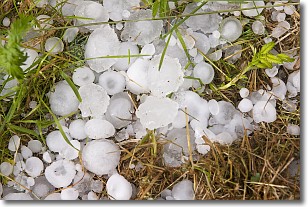
Weather Topic: What is Hail?
Home - Education - Precipitation - Hail
 Next Topic: Hole Punch Clouds
Hail is a form of precipitation which is recognized by large solid balls or
clumps of ice. Hail is created by thunderstorm clouds with strong updrafts of wind.
As the hailstones remain in the updraft, ice is deposited onto them until their
weight becomes heavy enough for them to fall to the earth's surface.
Hail storms can cause significant damage to crops, aircrafts, and man-made structures,
despite the fact that the duration is usually less than ten minutes.
Next Topic: Hole Punch Clouds
Weather Topic: What are Mammatus Clouds?
Home - Education - Cloud Types - Mammatus Clouds
 Next Topic: Nimbostratus Clouds
A mammatus cloud is a cloud with a unique feature which resembles
a web of pouches hanging along the base of the cloud.
In the United States, mammatus clouds tend to form in the warmer months, commonly
in the Midwest and eastern regions.
While they usually form at the bottom of a cumulonimbis cloud, they can also form
under altostratus, altocumulus, stratocumulus, and cirrus clouds. Mammatus clouds
warn that severe weather is close.
Next Topic: Nimbostratus Clouds
Current conditions powered by WeatherAPI.com


