Weather Alert in Arizona
Flash Flood Warning issued September 4 at 12:09PM MST until September 4 at 6:15PM MST by NWS Flagstaff AZ
AREAS AFFECTED: Coconino, AZ
DESCRIPTION: FFWFGZ The National Weather Service in Flagstaff has issued a * Flash Flood Warning for... The North Canyon Wash Basin downstream of the Dragon Bravo Fire scar in...Coconino County in north central Arizona...this includes the Colorado River between mile markers 17 and 21. * Until 615 PM MST /715 PM MDT/ Thursday. * At 1209 PM MST /109 PM MDT/, Doppler radar indicated thunderstorms producing heavy rain over the North Canyon Wash Basin downstream of the Dragon Bravo Fire scar. Flash flooding is ongoing or expected to begin shortly. Excessive rainfall over the burn scar will result in debris flow moving through the North Canyon Wash. The debris flow can consist of rock, mud, vegetation and other loose materials. HAZARD...Life threatening flash flooding. Thunderstorms producing flash flooding in and around the North Canyon Wash Basin downstream of the Dragon Bravo Fire scar. SOURCE...Radar indicated. IMPACT...Life threatening flash flooding of areas in and around the North Canyon Wash Basin downstream of the Dragon Bravo Fire scar. * Some locations that will experience flash flooding include... Grand Canyon National Park and Saddle Mountain Wilderness. This includes the Colorado River between mile markers 17 and 21. This includes the following recreation areas and campgrounds... House Rock Camp Site, 18 Mile Wash Camp Site, 18 Mile Ledges Camp Site, Upper North Canyon Camp Site and Lower North Canyon Camp Site. This includes the following creeks, washes and rivers... North Canyon, "18- Mile Wash", "19- Mile Canyon", Colorado River, South Canyon, House Rock Wash, Hanaa Ninadzidzahi and North Canyon Wash.
INSTRUCTION: Flash flooding is occurring or imminent downstream of the Dragon Bravo Fire scar. Severe debris flow are expected across roads and in remote canyon drainages on the Kaibab Plateau east of State Route 67. Campers and hikers should get away from creeks and move to higher ground immediately! Stay away or be swept away!
Want more detail? Get the Complete 7 Day and Night Detailed Forecast!
Current U.S. National Radar--Current
The Current National Weather Radar is shown below with a UTC Time (subtract 5 hours from UTC to get Eastern Time).

National Weather Forecast--Current
The Current National Weather Forecast and National Weather Map are shown below.

National Weather Forecast for Tomorrow
Tomorrow National Weather Forecast and Tomorrow National Weather Map are show below.

North America Water Vapor (Moisture)
This map shows recent moisture content over North America. Bright and colored areas show high moisture (ie, clouds); brown indicates very little moisture present; black indicates no moisture.

Weather Topic: What is Sleet?
Home - Education - Precipitation - Sleet
 Next Topic: Snow
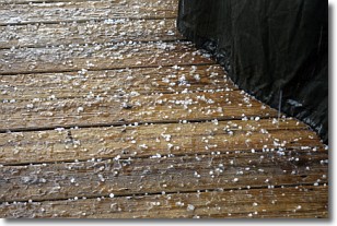
Sleet is a form of precipitation in which small ice pellets are the primary
components. These ice pellets are smaller and more translucent than hailstones,
and harder than graupel. Sleet is caused by specific atmospheric conditions and
therefore typically doesn't last for extended periods of time.
The condition which leads to sleet formation requires a warmer body of air to be
wedged in between two sub-freezing bodies of air. When snow falls through a warmer
layer of air it melts, and as it falls through the next sub-freezing body of air
it freezes again, forming ice pellets known as sleet. In some cases, water
droplets don't have time to freeze before reaching the surface and the result is
freezing rain.
Next Topic: Snow
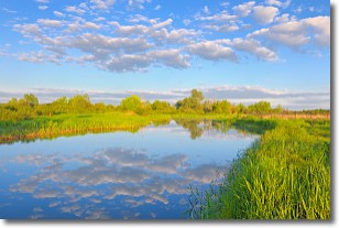
Weather Topic: What are Stratocumulus Clouds?
Home - Education - Cloud Types - Stratocumulus Clouds
 Next Topic: Stratus Clouds
Stratocumulus clouds are similar to altocumulus clouds in their
fluffy appearance, but have a slightly darker shade due to their additional mass.
A good way to distinguish the two cloud types is to hold your hand out and measure
the size of an individual cloud; if it is the size of your thumb it is generally
an altocumulus cloud, if it is the size of your hand it is generally a
stratocumulus cloud.
It is uncommon for stratocumulus clouds to produce precipitation, but if they do
it is usually a light rain or snow.
Next Topic: Stratus Clouds
Current conditions powered by WeatherAPI.com


