Weather Alert in California
Winter Weather Advisory issued April 25 at 1:22AM PDT until April 27 at 11:00AM PDT by NWS Reno NV
AREAS AFFECTED: Mono
DESCRIPTION: * WHAT...Snow. Snow accumulations of 3 to 6 inches along the Sierra crest with 10 to 12 inches along highest peaks, including the White Mountains. 1 to 3 inches for communities along Highway 395. Ridge winds gusting up to 50 mph. * WHERE...Mono County. * WHEN...From 5 PM this afternoon to 11 AM PDT Sunday. * IMPACTS...Travel could be difficult at times. The hazardous conditions could impact the Friday evening commute and weekend travel, especially across Sierra passes. * ADDITIONAL DETAILS...Heaviest snowfall expected Friday night and Saturday morning. Snow will struggle to accumulate on roadways during the daytime hours, though isolated heavy snow showers may bring greater accumulations Saturday afternoon.
INSTRUCTION: Slow down and use caution while traveling. The latest road conditions for the state you are calling from can be obtained by calling 5 1 1.
Want more detail? Get the Complete 7 Day and Night Detailed Forecast!
Current U.S. National Radar--Current
The Current National Weather Radar is shown below with a UTC Time (subtract 5 hours from UTC to get Eastern Time).

National Weather Forecast--Current
The Current National Weather Forecast and National Weather Map are shown below.

National Weather Forecast for Tomorrow
Tomorrow National Weather Forecast and Tomorrow National Weather Map are show below.

North America Water Vapor (Moisture)
This map shows recent moisture content over North America. Bright and colored areas show high moisture (ie, clouds); brown indicates very little moisture present; black indicates no moisture.

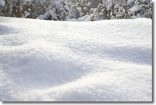
Weather Topic: What is Snow?
Home - Education - Precipitation - Snow
 Next Topic: Stratocumulus Clouds
Snow is precipitation taking the form of ice crystals. Each ice crystal, or snowflake,
has unique characteristics, but all of them grow in a hexagonal structure.
Snowfall can last for sustained periods of time and result in significant buildup
of snow on the ground.
On the earth's surface, snow starts out light and powdery, but as it begins to melt
it tends to become more granular, producing small bits of ice which have the consistency of
sand. After several cycles of melting and freezing, snow can become very dense
and ice-like, commonly known as snow pack.
Next Topic: Stratocumulus Clouds
Weather Topic: What are Stratus Clouds?
Home - Education - Cloud Types - Stratus Clouds
 Next Topic: Wall Clouds
Stratus clouds are similar to altostratus clouds, but form at a
lower altitude and are identified by their fog-like appearance, lacking the
distinguishing features of most clouds.
Stratus clouds are wider than most clouds, and their base has a smooth, uniform
look which is lighter in color than a nimbostratus cloud.
The presence of a stratus cloud indicates the possibility of minor precipitation,
such as drizzle, but heavier precipitation does not typically arrive in the form
of a stratus cloud.
Next Topic: Wall Clouds
Current conditions powered by WeatherAPI.com


