Weather Alert in Colorado
Flash Flood Warning issued August 26 at 2:37PM MDT until August 26 at 4:00PM MDT by NWS Grand Junction CO
AREAS AFFECTED: Rio Blanco, CO
DESCRIPTION: At 237 PM MDT, Trained weather spotters reported debris flows over the southwest corner of the Lee burn scar. Between 0.2 and 0.8 inches of rain have fallen. The expected rainfall rate is 0.2 to 0.6 inches in 30 minutes. Flash flooding is ongoing or expected to begin shortly. Excessive rainfall over the burn scar will result in debris flows which can can consist of rock, mud, vegetation and other loose materials. HAZARD...Flash flooding. Thunderstorms producing flash flooding in and around the Lee Southwest Corner Burn Scar. SOURCE...Trained spotters reported. IMPACT...Life threatening flash flooding of areas in and around the Lee Southwest Corner Burn Scar. Some locations that will experience flash flooding include... mainly rural areas of South Central Rio Blanco County This includes the following streams and drainages... West Fork Stewart Gulch, Dry Fork Piceance Creek, Dry Thirteenmile Creek, Main Prong Dry Fork Piceance Creek, Stewart Gulch, East Fork Stewart Gulch, Story Gulch and Piceance Creek.
INSTRUCTION: This is a life threatening situation. Heavy rainfall will cause extensive and severe flash flooding of creeks...streams...and ditches in the Burn Scar. Severe debris flows can also be anticipated across roads. Roads and driveways may be washed away in places. If you encounter flood waters...climb to safety. Move away from recently burned areas. Life-threatening flooding of creeks, roads and normally dry arroyos is likely. The heavy rains will likely trigger rockslides, mudslides and debris flows in steep terrain, especially in and around these areas.
Want more detail? Get the Complete 7 Day and Night Detailed Forecast!
Current U.S. National Radar--Current
The Current National Weather Radar is shown below with a UTC Time (subtract 5 hours from UTC to get Eastern Time).

National Weather Forecast--Current
The Current National Weather Forecast and National Weather Map are shown below.

National Weather Forecast for Tomorrow
Tomorrow National Weather Forecast and Tomorrow National Weather Map are show below.

North America Water Vapor (Moisture)
This map shows recent moisture content over North America. Bright and colored areas show high moisture (ie, clouds); brown indicates very little moisture present; black indicates no moisture.

Weather Topic: What are Altostratus Clouds?
Home - Education - Cloud Types - Altostratus Clouds
 Next Topic: Cirrocumulus Clouds
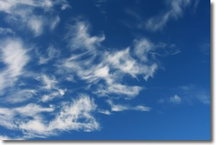
Altostratus clouds form at mid to high-level altitudes
(between 2 and 7 km) and are created by a warm, stable air mass which causes
water vapor
to condense as it rise through the atmosphere. Usually altostratus clouds are
featureless sheets characterized by a uniform color.
In some cases, wind punching through the cloud formation may give it a waved
appearance, called altostratus undulatus. Altostratus clouds
are commonly seen with other cloud formations accompanying them.
Next Topic: Cirrocumulus Clouds
Weather Topic: What are Cirrostratus Clouds?
Home - Education - Cloud Types - Cirrostratus Clouds
 Next Topic: Cirrus Clouds
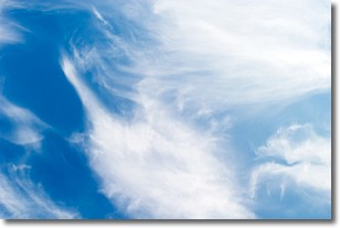
Cirrostratus clouds are high, thin clouds that form above
20,000 feet and are made mostly of ice crystals. They sometimes look like giant
feathers, horse tails, or curls of hair in the sky.
These clouds are pushed by the jet stream and can move at high speeds reaching
100 mph.
What do they indicate?
They indicate that a precipitation is likely within 24 hours.
Next Topic: Cirrus Clouds
Current conditions powered by WeatherAPI.com


