Weather Alert in California
Fire Weather Watch issued August 31 at 1:11PM PDT until September 2 at 8:00PM PDT by NWS Eureka CA
AREAS AFFECTED: Lower Middle Klamath; W Mendocino NF/E Mendocino Unit; Trinity
DESCRIPTION: ...ISOLATED DRY THUNDERSTORMS TUESDAY AFTERNOON AND EARLY EVENING... .Isolated dry thunderstorms are expected over the interior high terrain Tuesday afternoon and into early evening. Threats include erratic gusty winds and lightning. Lightning on dry fuels may lead to new fire starts. In addition, gusty winds combined with hot temperatures and low relative humidity will produce critical fire weather conditions. Existing fires and any new fire will have the potential to spread rapidly. The National Weather Service in Eureka has issued a Fire Weather Watch, which is in effect from Tuesday afternoon through Tuesday evening. * AFFECTED AREA...Fire weather zone 204.Fire weather zone 277.Fire weather zone 283. * THUNDERSTORMS...Isolated dry storms over high terrain in the afternoon and early evening hours. * OUTFLOW WINDS...Gusty and erratic outflow winds over 35 mph. * IMPACTS...any fires that develop will likely spread rapidly. Outdoor burning is not recommended.
INSTRUCTION: A Fire Weather Watch means that critical fire weather conditions are forecast to occur. Listen for later forecasts and possible Red Flag Warnings.
Want more detail? Get the Complete 7 Day and Night Detailed Forecast!
Current U.S. National Radar--Current
The Current National Weather Radar is shown below with a UTC Time (subtract 5 hours from UTC to get Eastern Time).

National Weather Forecast--Current
The Current National Weather Forecast and National Weather Map are shown below.

National Weather Forecast for Tomorrow
Tomorrow National Weather Forecast and Tomorrow National Weather Map are show below.

North America Water Vapor (Moisture)
This map shows recent moisture content over North America. Bright and colored areas show high moisture (ie, clouds); brown indicates very little moisture present; black indicates no moisture.

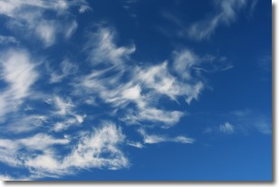
Weather Topic: What are Cirrostratus Clouds?
Home - Education - Cloud Types - Cirrostratus Clouds
 Next Topic: Cirrus Clouds
Cirrostratus clouds are high, thin clouds that form above
20,000 feet and are made mostly of ice crystals. They sometimes look like giant
feathers, horse tails, or curls of hair in the sky.
These clouds are pushed by the jet stream and can move at high speeds reaching
100 mph.
What do they indicate?
They indicate that a precipitation is likely within 24 hours.
Next Topic: Cirrus Clouds
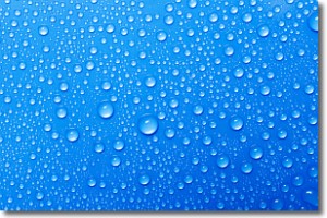
Weather Topic: What is Condensation?
Home - Education - Precipitation - Condensation
 Next Topic: Contrails
Condensation is the process which creates clouds, and therefore
it is a crucial process in the water cycle.
Condensation is the change of matter from a state of gas into a state of liquid,
and it happens because water molecules release heat into the atmosphere and
become organized into a more closely packed structure, what we might see as
water droplets.
Water is always present in the air around us as a vapor, but it's too small for
us to see. When water undergoes the process of condensation it becomes organized
into visible water droplets. You've probably seen condensation happen before on the
surface of a cold drink!
Next Topic: Contrails
Current conditions powered by WeatherAPI.com


