Weather Alert in Montana
Winter Weather Advisory issued February 23 at 1:36PM MST until February 24 at 5:00AM MST by NWS Missoula MT
AREAS AFFECTED: West Glacier Region
DESCRIPTION: ...WINTRY MIX IN VALLEYS AND HEAVY MOUNTAIN SNOW... .A transition from rain to wet snow tonight will lead to slick road conditions for the Tuesday morning commute across West-Central Montana. While snowfall amounts will be light to moderate, the slushy nature of the snow with slick conditions are the primary concerns as temperatures drop below freezing on wet surfaces. * WHAT...Snow expected. There is a likelihood of minor to moderate winter weather impacts. Total snow accumulations of 1 to 4 inches in the valleys and 4 to 7 inches from Essex to Marias Pass. Higher amounts are expected in the higher terrain. Winds gusting as high as 35 mph. * WHERE...Marias Pass, Essex, Highway 83 Bigfork to Swan Lake, Polebridge, Glacier National Park, and Bad Rock Canyon. * WHEN...Until 5 AM MST Tuesday. * IMPACTS...Winter traveling conditions. For MODERATE winter weather impacts, expect disruptions to normal activities. Hazardous traveling conditions. Use extra caution while driving. Closures and disruptions to infrastructure may occur.
INSTRUCTION: Slow down and use caution while traveling. The latest road conditions for the state you are calling from can be obtained by calling 5 1 1.
Want more detail? Get the Complete 7 Day and Night Detailed Forecast!
Current U.S. National Radar--Current
The Current National Weather Radar is shown below with a UTC Time (subtract 5 hours from UTC to get Eastern Time).

National Weather Forecast--Current
The Current National Weather Forecast and National Weather Map are shown below.

National Weather Forecast for Tomorrow
Tomorrow National Weather Forecast and Tomorrow National Weather Map are show below.

North America Water Vapor (Moisture)
This map shows recent moisture content over North America. Bright and colored areas show high moisture (ie, clouds); brown indicates very little moisture present; black indicates no moisture.

Weather Topic: What are Contrails?
Home - Education - Cloud Types - Contrails
 Next Topic: Cumulonimbus Clouds
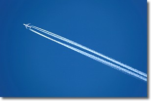
A contrail is an artificial cloud, created by the passing of an
aircraft.
Contrails form because water vapor in the exhaust of aircraft engines is suspended
in the air under certain temperatures and humidity conditions. These contrails
are called exhaust contrails.
Another type of contrail can form due to a temporary reduction in air pressure
moving over the plane's surface, causing condensation.
These are called aerodynamic contrails.
When you can see your breath on a cold day, it is also because of condensation.
The reason contrails last longer than the condensation from your breath is
because the water in contrails freezes into ice particles.
Next Topic: Cumulonimbus Clouds
Weather Topic: What are Cumulus Clouds?
Home - Education - Cloud Types - Cumulus Clouds
 Next Topic: Drizzle
Cumulus clouds are fluffy and textured with rounded tops, and
may have flat bottoms. The border of a cumulus cloud
is clearly defined, and can have the appearance of cotton or cauliflower.
Cumulus clouds form at low altitudes (rarely above 2 km) but can grow very tall,
becoming cumulus congestus and possibly the even taller cumulonimbus clouds.
When cumulus clouds become taller, they have a greater chance of producing precipitation.
Next Topic: Drizzle
Current conditions powered by WeatherAPI.com


