Weather Alert in Arizona
Extreme Heat Watch issued June 11 at 12:49PM MST until June 16 at 8:00PM MST by NWS Phoenix AZ
AREAS AFFECTED: Northwest Valley; Buckeye/Avondale; Cave Creek/New River; Deer Valley; Central Phoenix; North Phoenix/Glendale; Scottsdale/Paradise Valley; East Valley; Fountain Hills/East Mesa; South Mountain/Ahwatukee; Southeast Valley/Queen Creek
DESCRIPTION: * WHAT...Dangerously hot conditions possible. Afternoon temperatures 106 to 114. Major Heat Risk. Overexposure can cause heat cramps and heat exhaustion to develop and, without intervention, can lead to heat stroke. * WHERE...A portion of south central Arizona, including the Phoenix Metro. * WHEN...From Saturday morning through Monday evening. * IMPACTS...Heat related illnesses increase significantly during extreme heat events. * ADDITIONAL DETAILS...In Maricopa County, call 2 1 1 to find a free cooling center, transportation, water, and more. https://www.maricopa.gov/heat
INSTRUCTION: An Extreme Heat Watch means that a period of very hot temperatures, even by local standards, may occur. Actions should be taken to lessen the impact of the extreme heat. Take extra precautions if you work or spend time outside. When possible, reschedule strenuous activities to early morning or evening. Know the signs and symptoms of heat exhaustion and heat stroke. Wear lightweight and loose-fitting clothing when possible and drink plenty of water. To reduce risk during outdoor work, the Occupational Safety and Health Administration recommends scheduling frequent rest breaks in shaded or air conditioned environments. Anyone overcome by heat should be moved to a cool and shaded location. Heat stroke is an emergency! Call 9 1 1. Public cooling shelters are available in some areas. Consult county officials for more details.
Want more detail? Get the Complete 7 Day and Night Detailed Forecast!
Current U.S. National Radar--Current
The Current National Weather Radar is shown below with a UTC Time (subtract 5 hours from UTC to get Eastern Time).

National Weather Forecast--Current
The Current National Weather Forecast and National Weather Map are shown below.

National Weather Forecast for Tomorrow
Tomorrow National Weather Forecast and Tomorrow National Weather Map are show below.

North America Water Vapor (Moisture)
This map shows recent moisture content over North America. Bright and colored areas show high moisture (ie, clouds); brown indicates very little moisture present; black indicates no moisture.

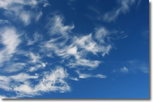
Weather Topic: What are Altostratus Clouds?
Home - Education - Cloud Types - Altostratus Clouds
 Next Topic: Cirrocumulus Clouds
Altostratus clouds form at mid to high-level altitudes
(between 2 and 7 km) and are created by a warm, stable air mass which causes
water vapor
to condense as it rise through the atmosphere. Usually altostratus clouds are
featureless sheets characterized by a uniform color.
In some cases, wind punching through the cloud formation may give it a waved
appearance, called altostratus undulatus. Altostratus clouds
are commonly seen with other cloud formations accompanying them.
Next Topic: Cirrocumulus Clouds
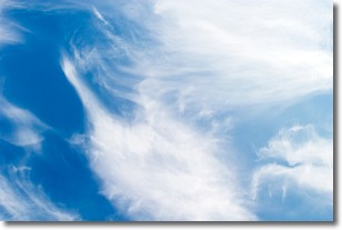
Weather Topic: What are Cirrostratus Clouds?
Home - Education - Cloud Types - Cirrostratus Clouds
 Next Topic: Cirrus Clouds
Cirrostratus clouds are high, thin clouds that form above
20,000 feet and are made mostly of ice crystals. They sometimes look like giant
feathers, horse tails, or curls of hair in the sky.
These clouds are pushed by the jet stream and can move at high speeds reaching
100 mph.
What do they indicate?
They indicate that a precipitation is likely within 24 hours.
Next Topic: Cirrus Clouds
Current conditions powered by WeatherAPI.com


