Weather Alert in Texas
Special Weather Statement issued September 6 at 2:53PM CDT by NWS Austin/San Antonio TX
AREAS AFFECTED: Val Verde; Kinney
DESCRIPTION: At 253 PM CDT, Doppler radar was tracking a strong thunderstorm 9 miles east of Long Point, or 12 miles north of Del Rio, moving southeast at 25 mph. HAZARD...Wind gusts up to 50 mph and half inch hail. SOURCE...Radar indicated. IMPACT...Gusty winds could knock down tree limbs and blow around unsecured objects. Minor damage to outdoor objects is possible. Locations impacted include... Del Rio, Brackettville, Standart, Alamo Village, Amanda, Laughlin AFB, Long Point, Val Verde Park, 277 North Campground, Escondido Estates, 277 South Boat Ramp, and San Pedro Canyon.
INSTRUCTION: If outdoors, consider seeking shelter inside a building. Torrential rainfall is also occurring with this storm and may lead to localized flooding. Do not drive your vehicle through flooded roadways. Frequent cloud to ground lightning is occurring with this storm. Lightning can strike 10 miles away from a thunderstorm. Seek a safe shelter inside a building or vehicle. If on or near Lake Amistad, get out of the water and move indoors or inside a vehicle. Remember, lightning can strike out to 10 miles from the parent thunderstorm. If you can hear thunder, you are close enough to be struck by lightning. Move to safe shelter now! Do not be caught on the water in a thunderstorm.
Want more detail? Get the Complete 7 Day and Night Detailed Forecast!
Current U.S. National Radar--Current
The Current National Weather Radar is shown below with a UTC Time (subtract 5 hours from UTC to get Eastern Time).

National Weather Forecast--Current
The Current National Weather Forecast and National Weather Map are shown below.

National Weather Forecast for Tomorrow
Tomorrow National Weather Forecast and Tomorrow National Weather Map are show below.

North America Water Vapor (Moisture)
This map shows recent moisture content over North America. Bright and colored areas show high moisture (ie, clouds); brown indicates very little moisture present; black indicates no moisture.

Weather Topic: What is Drizzle?
Home - Education - Precipitation - Drizzle
 Next Topic: Evaporation
Drizzle is precipitation in the form of water droplets which are
smaller than raindrops.
Drizzle is characterized by fine, gently falling droplets and typically does not
impact human habitation in a negative way. The exception to this is freezing drizzle,
a condition where drizzle freezes immediately upon reaching earth's surface.
Freezing drizzle is still less dangerous than freezing rain, but can
potentially result in hazardous road conditions.
Next Topic: Evaporation
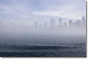
Weather Topic: What is Fog?
Home - Education - Cloud Types - Fog
 Next Topic: Fractus Clouds
Fog is technically a type of stratus cloud, which lies along the
ground and obscures visibility.
It is usually created when humidity in the air condenses into tiny water droplets.
Because of this, some places are more prone to foggy weather, such as regions
close to a body of water.
Fog is similar to mist; both are the appearance of water droplets suspended in
the air, but fog is the term applied to the condition when visibility is less than 1 km.
Next Topic: Fractus Clouds
Current conditions powered by WeatherAPI.com


