Weather Alert in Minnesota
Winter Weather Advisory issued March 31 at 2:50PM CDT until April 2 at 7:00PM CDT by NWS Twin Cities/Chanhassen MN
AREAS AFFECTED: Sherburne; Isanti; Chisago; Wright; Hennepin; Anoka; Ramsey; Washington; Renville; McLeod; Sibley; Carver; Scott; Dakota; Redwood; Brown; Nicollet; Le Sueur; Rice; Goodhue; Watonwan; Blue Earth; Waseca; Steele
DESCRIPTION: ...MESSY SPRING SYSTEM TO BRING RAIN, FREEZING RAIN, SLEET, AND SNOW TO PORTIONS OF MINNESOTA AND WISCONSIN WEDNESDAY THROUGH THURSDAY... .A strong system is expected to bring a variety of precipitation types to the region Wednesday through Thursday. While there is still some uncertainty in the exact track of the low, a mix of snow and sleet is expected for much of central and western Minnesota. Further to the south and east, sleet and freezing rain will be the primary precipitation type. Some shifts in the track are still anticipated, which will influence the total accumulations of snow, sleet, freezing rain, and rain. * WHAT...Mixed precipitation expected. Total snow accumulations up to 3 inches, sleet accumulations around 1 inch, and ice accumulations up to one tenth of an inch. * WHERE...Portions of central, east central, south central, southeast, and southwest Minnesota. * WHEN...From 7 PM Wednesday to 7 PM CDT Thursday. * IMPACTS...Plan on slippery road conditions. The hazardous conditions will impact the Wednesday evening and Thursday morning commutes.
INSTRUCTION: Slow down and use caution while traveling. Call 5 1 1 or visit 511mn.org for road conditions.
Want more detail? Get the Complete 7 Day and Night Detailed Forecast!
Current U.S. National Radar--Current
The Current National Weather Radar is shown below with a UTC Time (subtract 5 hours from UTC to get Eastern Time).

National Weather Forecast--Current
The Current National Weather Forecast and National Weather Map are shown below.

National Weather Forecast for Tomorrow
Tomorrow National Weather Forecast and Tomorrow National Weather Map are show below.

North America Water Vapor (Moisture)
This map shows recent moisture content over North America. Bright and colored areas show high moisture (ie, clouds); brown indicates very little moisture present; black indicates no moisture.

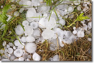
Weather Topic: What is Hail?
Home - Education - Precipitation - Hail
 Next Topic: Hole Punch Clouds
Hail is a form of precipitation which is recognized by large solid balls or
clumps of ice. Hail is created by thunderstorm clouds with strong updrafts of wind.
As the hailstones remain in the updraft, ice is deposited onto them until their
weight becomes heavy enough for them to fall to the earth's surface.
Hail storms can cause significant damage to crops, aircrafts, and man-made structures,
despite the fact that the duration is usually less than ten minutes.
Next Topic: Hole Punch Clouds
Weather Topic: What are Mammatus Clouds?
Home - Education - Cloud Types - Mammatus Clouds
 Next Topic: Nimbostratus Clouds
A mammatus cloud is a cloud with a unique feature which resembles
a web of pouches hanging along the base of the cloud.
In the United States, mammatus clouds tend to form in the warmer months, commonly
in the Midwest and eastern regions.
While they usually form at the bottom of a cumulonimbis cloud, they can also form
under altostratus, altocumulus, stratocumulus, and cirrus clouds. Mammatus clouds
warn that severe weather is close.
Next Topic: Nimbostratus Clouds
Current conditions powered by WeatherAPI.com


