Weather Alert in Maine
Blizzard Warning issued February 22 at 3:46PM EST until February 23 at 10:00PM EST by NWS Gray ME
AREAS AFFECTED: Coastal York; Coastal Cumberland; Sagadahoc; Lincoln; Knox; Coastal Waldo
DESCRIPTION: * WHAT...Blizzard conditions expected. Total snow accumulations between 6 and 10 inches. Wind gusts in excess of 40 mph possible... especially along the immediate coast. * WHERE...Portions of south central and southwest Maine. * WHEN...From 7 AM to 10 PM EST Monday. * IMPACTS...Whiteout conditions are expected with visibilities below 1/4 mile due to falling and blowing snow. The greatest potential for blizzard conditions will exist late morning through afternoon Monday. The hazardous conditions will arrive during the Monday morning commute and will continue through the evening commute. Strong winds will down tree limbs and blow around unsecured objects. A Few trees and power lines could be downed. The power outage threat is elevated.
INSTRUCTION: Travel should be restricted to emergencies only. If you must travel, have a winter survival kit with you. If you get stranded, stay with your vehicle. The latest road conditions can be obtained by going to newengland511.org Persons should consider delaying all travel. Motorists should use extreme caution if travel is absolutely necessary.
Want more detail? Get the Complete 7 Day and Night Detailed Forecast!
Current U.S. National Radar--Current
The Current National Weather Radar is shown below with a UTC Time (subtract 5 hours from UTC to get Eastern Time).

National Weather Forecast--Current
The Current National Weather Forecast and National Weather Map are shown below.

National Weather Forecast for Tomorrow
Tomorrow National Weather Forecast and Tomorrow National Weather Map are show below.

North America Water Vapor (Moisture)
This map shows recent moisture content over North America. Bright and colored areas show high moisture (ie, clouds); brown indicates very little moisture present; black indicates no moisture.

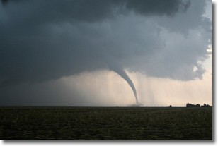
Weather Topic: What are Wall Clouds?
Home - Education - Cloud Types - Wall Clouds
 Next Topic: Altocumulus Clouds
A wall cloud forms underneath the base of a cumulonimbus cloud,
and can be a hotbed for deadly tornadoes.
Wall clouds are formed by air flowing into the cumulonimbus clouds, which can
result in the wall cloud descending from the base of the cumulonimbus cloud, or
rising fractus clouds which join to the base of the storm cloud as the wall cloud
takes shape.
Wall clouds can be very large, and in the Northern Hemisphere they generally
form at the southern edge of cumulonimbus clouds.
Next Topic: Altocumulus Clouds
Weather Topic: What are Altostratus Clouds?
Home - Education - Cloud Types - Altostratus Clouds
 Next Topic: Cirrocumulus Clouds
Altostratus clouds form at mid to high-level altitudes
(between 2 and 7 km) and are created by a warm, stable air mass which causes
water vapor
to condense as it rise through the atmosphere. Usually altostratus clouds are
featureless sheets characterized by a uniform color.
In some cases, wind punching through the cloud formation may give it a waved
appearance, called altostratus undulatus. Altostratus clouds
are commonly seen with other cloud formations accompanying them.
Next Topic: Cirrocumulus Clouds
Current conditions powered by WeatherAPI.com


