Weather Alert in Oregon
Red Flag Warning issued August 24 at 12:58PM PDT until August 25 at 9:00PM PDT by NWS Pendleton OR
AREAS AFFECTED: Central Mountains of Oregon; Northern Deschutes National Forest
DESCRIPTION: ...HOT, DRY, AND UNSTABLE CONDITIONS EXPECTED IN CENTRAL OREGON OVER THE NEXT TWO DAYS... .Hot conditions, combined with low relative humidities and an unstable air mass, have the potential to create significant, plume-dominated fire growth in the area surrounding the Flat Fire. Unstable conditions will relent overnight, however relative humidity recoveries are expected to be poor. * AFFECTED AREA...Fire Weather Zones 700 Central Mountains of Oregon and 704 Northern Deschutes National Forest. * TIMING...Until 9 PM PDT Monday. * MIXING HEIGHT...As high as 8,000 ft AGL Today and 11,500 ft AGL Monday. * RELATIVE HUMIDITY...As low as 15 percent. * IMPACTS...Any fire that develops will catch and spread quickly. Outdoor burning is not recommended.
INSTRUCTION: A Red Flag Warning means that critical fire weather conditions are either occurring now, or will shortly. A combination of strong winds, low relative humidity, and warm temperatures can contribute to extreme fire behavior.
Want more detail? Get the Complete 7 Day and Night Detailed Forecast!
Current U.S. National Radar--Current
The Current National Weather Radar is shown below with a UTC Time (subtract 5 hours from UTC to get Eastern Time).

National Weather Forecast--Current
The Current National Weather Forecast and National Weather Map are shown below.

National Weather Forecast for Tomorrow
Tomorrow National Weather Forecast and Tomorrow National Weather Map are show below.

North America Water Vapor (Moisture)
This map shows recent moisture content over North America. Bright and colored areas show high moisture (ie, clouds); brown indicates very little moisture present; black indicates no moisture.

Weather Topic: What is Condensation?
Home - Education - Precipitation - Condensation
 Next Topic: Contrails
Condensation is the process which creates clouds, and therefore
it is a crucial process in the water cycle.
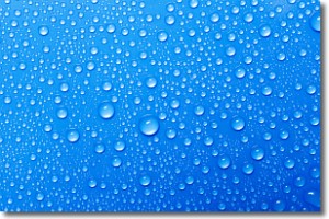
Condensation is the change of matter from a state of gas into a state of liquid,
and it happens because water molecules release heat into the atmosphere and
become organized into a more closely packed structure, what we might see as
water droplets.
Water is always present in the air around us as a vapor, but it's too small for
us to see. When water undergoes the process of condensation it becomes organized
into visible water droplets. You've probably seen condensation happen before on the
surface of a cold drink!
Next Topic: Contrails
Weather Topic: What are Cumulonimbus Clouds?
Home - Education - Cloud Types - Cumulonimbus Clouds
 Next Topic: Cumulus Clouds
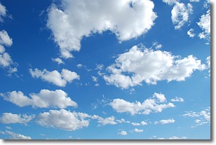
The final form taken by a growing cumulus cloud is the
cumulonimbus cloud, which is very tall and dense.
The tower of a cumulonimbus cloud can soar 23 km into the atmosphere, although
most commonly they stop growing at an altitude of 6 km.
Even small cumulonimbus clouds appear very large in comparison to other cloud types.
They can signal the approach of stormy weather, such as thunderstorms or blizzards.
Next Topic: Cumulus Clouds
Current conditions powered by WeatherAPI.com


