Weather Alert in Wisconsin
Flood Warning issued April 3 at 9:26PM CDT by NWS Green Bay WI
AREAS AFFECTED: Outagamie, WI; Shawano, WI; Waupaca, WI
DESCRIPTION: ...The Flood Warning is extended for the following rivers in Wisconsin... Wolf River near Shiocton affecting Outagamie, Shawano and Waupaca Counties. For the Lower Wolf River...including Shiocton...Minor flooding is forecast. * WHAT...Minor flooding is forecast. * WHERE...Wolf River near Shiocton. * WHEN...From Saturday morning until further notice. * IMPACTS...At 12.5 feet, There is widespread lowland flooding. Water is surrounding structures along the river near Island and Mill Streets. * ADDITIONAL DETAILS... - At 7:30 AM CDT Friday the stage was 10.4 feet. - Bankfull stage is 9.0 feet. - Forecast...The river is expected to rise above flood stage tomorrow morning and continue rising to a crest of 12.3 feet early Tuesday morning. - Flood stage is 11.0 feet. - http://www.weather.gov/safety/flood
INSTRUCTION: Turn around, don't drown when encountering flooded roads. Most flood deaths occur in vehicles. Motorists should not attempt to drive around barricades or drive cars through flooded areas. Additional information is available at www.weather.gov. The next statement will be issued Saturday afternoon by 1230 PM CDT.
Want more detail? Get the Complete 7 Day and Night Detailed Forecast!
Current U.S. National Radar--Current
The Current National Weather Radar is shown below with a UTC Time (subtract 5 hours from UTC to get Eastern Time).

National Weather Forecast--Current
The Current National Weather Forecast and National Weather Map are shown below.

National Weather Forecast for Tomorrow
Tomorrow National Weather Forecast and Tomorrow National Weather Map are show below.

North America Water Vapor (Moisture)
This map shows recent moisture content over North America. Bright and colored areas show high moisture (ie, clouds); brown indicates very little moisture present; black indicates no moisture.

Weather Topic: What are Cirrus Clouds?
Home - Education - Cloud Types - Cirrus Clouds
 Next Topic: Condensation
Cirrus clouds are high-level clouds that occur above 20,000 feet
and are composed mainly of ice crystals.
They are thin and wispy in appearance.
What do they indicate?
They are often the first sign of an approaching storm.
Next Topic: Condensation
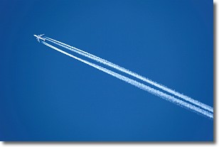
Weather Topic: What are Contrails?
Home - Education - Cloud Types - Contrails
 Next Topic: Cumulonimbus Clouds
A contrail is an artificial cloud, created by the passing of an
aircraft.
Contrails form because water vapor in the exhaust of aircraft engines is suspended
in the air under certain temperatures and humidity conditions. These contrails
are called exhaust contrails.
Another type of contrail can form due to a temporary reduction in air pressure
moving over the plane's surface, causing condensation.
These are called aerodynamic contrails.
When you can see your breath on a cold day, it is also because of condensation.
The reason contrails last longer than the condensation from your breath is
because the water in contrails freezes into ice particles.
Next Topic: Cumulonimbus Clouds
Current conditions powered by WeatherAPI.com


