Weather Alert in Alaska
Special Weather Statement issued February 22 at 2:03PM AKST by NWS Juneau AK
AREAS AFFECTED: City and Borough of Yakutat; Municipality of Skagway; Haines Borough and Klukwan; Glacier Bay; Eastern Chichagof Island; Cape Fairweather to Lisianski Strait; City and Borough of Sitka; Admiralty Island; City and Borough of Juneau; Petersburg Borough; Western Kupreanof and Kuiu Island; City and Borough of Wrangell
DESCRIPTION: A pattern change begins Tuesday as clear and cold conditions give way to accumulating snow for the panhandle by the middle of the week as a system moves in from the northern Gulf. Current expectation is snow will be slow to accumulate, with this event proving to be longer in duration with forecast accumulations around 4 to 8 inches of snow starting Tuesday through Thursday. Highest snowfall totals will be for areas north of Sumner Strait, though a brief period of warming conditions late Tuesday will see some areas of the central panhandle change over to rain briefly, before cooler air returns through Wednesday. Thursday will see snow showers become increasingly predominant, with highly variable snow accumulations expected as the low moves south. Stay tuned for latest forecast updates at weather.gov/juneau
INSTRUCTION: N/A
Want more detail? Get the Complete 7 Day and Night Detailed Forecast!
Current U.S. National Radar--Current
The Current National Weather Radar is shown below with a UTC Time (subtract 5 hours from UTC to get Eastern Time).

National Weather Forecast--Current
The Current National Weather Forecast and National Weather Map are shown below.

National Weather Forecast for Tomorrow
Tomorrow National Weather Forecast and Tomorrow National Weather Map are show below.

North America Water Vapor (Moisture)
This map shows recent moisture content over North America. Bright and colored areas show high moisture (ie, clouds); brown indicates very little moisture present; black indicates no moisture.

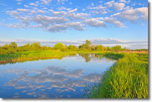
Weather Topic: What are Stratocumulus Clouds?
Home - Education - Cloud Types - Stratocumulus Clouds
 Next Topic: Stratus Clouds
Stratocumulus clouds are similar to altocumulus clouds in their
fluffy appearance, but have a slightly darker shade due to their additional mass.
A good way to distinguish the two cloud types is to hold your hand out and measure
the size of an individual cloud; if it is the size of your thumb it is generally
an altocumulus cloud, if it is the size of your hand it is generally a
stratocumulus cloud.
It is uncommon for stratocumulus clouds to produce precipitation, but if they do
it is usually a light rain or snow.
Next Topic: Stratus Clouds
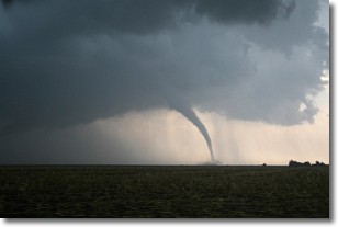
Weather Topic: What are Wall Clouds?
Home - Education - Cloud Types - Wall Clouds
 Next Topic: Altocumulus Clouds
A wall cloud forms underneath the base of a cumulonimbus cloud,
and can be a hotbed for deadly tornadoes.
Wall clouds are formed by air flowing into the cumulonimbus clouds, which can
result in the wall cloud descending from the base of the cumulonimbus cloud, or
rising fractus clouds which join to the base of the storm cloud as the wall cloud
takes shape.
Wall clouds can be very large, and in the Northern Hemisphere they generally
form at the southern edge of cumulonimbus clouds.
Next Topic: Altocumulus Clouds
Current conditions powered by WeatherAPI.com


